

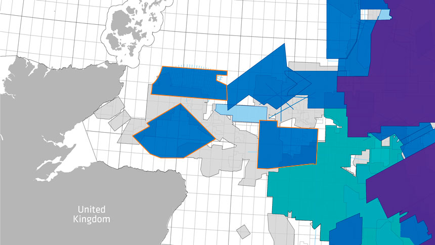
Final depth imaging of three MultiClient 3D GeoStreamer surveys is complete and covers nearly 7 400 sq. km of the Moray Firth area of the North Sea. Primary targets are located in the proven Upper Jurassic and Lower Cretaceous plays. The multisensor datasets provide an excellent basis for exploration decisions and can also be used as baseline surveys for future 4D studies. The broadband uplift will provide a significant improvement in understanding and unlocking the potential in the Orcadian Basin in both mature and frontier areas.
The surveys enhance understanding of prospectivity of the mature Outer Moray Firth area and provide exploratory datasets around the West Bank High area, the Wick Sub-basin, and Caithness Ridge. The surveys are listed below and bordered in orange in the figure.
- Phase 1: eastern Moray Firth, PGS18001MOF
- Phase 2: western Moray Firth, PGS18002MOF
- Phase 3: northern Moray Firth, PGS18003MOF
Prospective Sandstones of the Outer Moray Firth
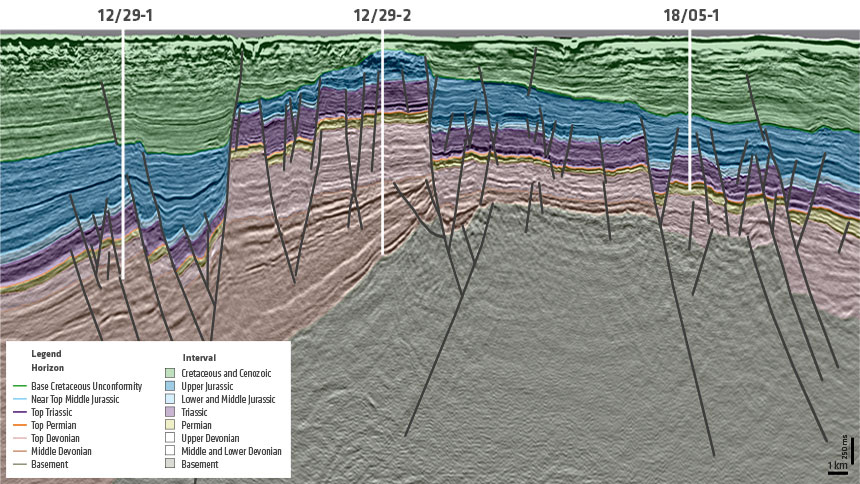
The eastern Moray Firth survey targets Paleocene prospectivity as well as the Upper Jurassic–Lower Cretaceous sandstone reservoirs sourced by the Kimmeridge Clay Formation. The survey follows the Lower Cretaceous sandstone fairway of the Britannia and Captain sandstones entering the area from the north through the Witch Ground Graben and provides detailed imaging of a paleo shoreface shelf break, revealing low and high sea-level stands useful for local correlative sequence stratigraphy.
Imaging of the reservoirs and petroleum systems of this mature area is significantly improved by high-quality GeoStreamer 3D seismic data. Quantitative interpretation reveals very thin sand stringers in the Upper Jurassic, sourced by the Kimmeridge Clay, and potential up-dip hydrocarbon migration through sandstones. Good AVO correlation enables nearfield exploration.
Brora Coals and Kimmeridge Clay Source Rocks
The western survey covers an immature area of the Inner Moray Firth and reveals Devonian–Lower Cretaceous sandstone reservoirs, with source rock potential in the Devonian, Middle, and Upper Jurassic, and even within the Cretaceous. The survey incorporates the West Bank High atop the Orcadian Basin, flanked by the Smith Graben to the north-west, and the Banff Sub-basin to the east.
High-density GeoStreamer data is a significant upgrade to the previous sparse, mainly 2D data available for this region. Initial sediment buildup in the Orcadian Basin is well imaged and enables mapping out of the lacustrine environment. The Brora coals and analog plays to the Beatrice field are situated to the west of the West Bank High, while the recognized Kimmeridge Clay is the more established source rock on the Banff side.
The Wick Sub-Basin and the Koppervik Fairway
The third survey focuses on the innermost area of the Moray Firth North, which, like the western survey, is frontier and provides new and significantly improved coverage. The key challenge in the area is the combination of masked deep structures, shallow water, and complex shallow Chalk Group overburden. High-density GeoStreamer data and modern imaging technology will help to uncover the source and the reservoir potential.
Wells in the area indicate the petroleum system is working and is most likely sourced from the Wick Sub-basin. The survey will help determine the entry point(s) of the Lower Cretaceous sandstones that are part of the Koppervik Fairway.
Find Out More
To view the data, or for more information, please contact europe.info@pgs.com
Contact a PGS expert
Please contact a member of our AMME team for more information.