

PGS this month reveals the first data from a pioneering acquisition configuration deployed in the Viking Graben in the autumn of 2019. Three months after the last shot on the GeoStreamer X survey, the early-out multi-azimuth (MAZ) PSDM seismic stack was delivered to prefunders.
From an interpreter’s point of view the results are stunning, and what started as a novel concept now provides new insight to geoscience teams in near-field exploration, appraisal, and development.
Read the full article GeoStreamer X in the Viking Graben Illuminates Complex Targets, and watch our 15-minute GeoStreamer X webinar.
GeoStreamer X is tailored to the geological and geophysical challenges of the area and delivers a faster, smarter solution to nodes, with a significantly reduced environmental footprint.
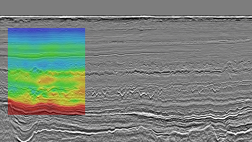
The early-out PSDM full-stack seismic section below reveals sharper faults in the Tertiary section and radically improved reflection continuity in the Paleocene and Jurassic section, refining seismic interpretation and derisking the location of the source, reservoir targets, trap size, and competency.
GeoStreamer X | Multiple Benefits
Our pioneering new acquisition configuration used for this survey, GeoStreamer X, combines wide-towed sources close to the multisensor streamers with longer offsets and multi-azimuths. The GeoStreamer X Viking Graben survey demonstrates full coverage of reliable near offsets in the 50–125 m range, as well as two new azimuths and used a 12 × 6 km × 85 m high-density streamer spread, including two 10 km long streamer tails, and a wide-towed triple source with 225 m separation between outer source arrays. These additional azimuths are complementary to the existing GeoStreamer MultiClient data coverage from 2011.
The result is a high-resolution, multi azimuth illumination seismic dataset with an accurate velocity model and robust and reliable AVO attributes. It is suitable for near-field exploration, appraisal, and development.
Define Challenge – Apply Technology
There are many targets in the area, ranging from Eocene sand injectites to fractured basement. An approach integrating survey design, imaging solutions, and quantitative interpretation has enabled a significant improvement in the resolution of these reservoirs. The main imaging challenges include large shallow channels and massive sand mounds in the Miocene as these introduce shadow zones beneath them. Eocene cemented sand injectites, called V-brights, have anomalously high velocities which historically have been very difficult to estimate. Deeper, a thin, rugose Cretaceous chalk layer causes multiples and dispersion of the seismic energy.
GeoStreamer X is a flexible acquisition and imaging integrated solution tailored to the geological and geophysical challenges, be it illumination and resolution of injectites in the Viking Graben, shallow targets in shallow water such as in the Barents Sea or better illumination around salt structures in Brazil.
The ambitious goal of GeoStreamer X is to deliver a step change for improved reservoir insight. Using a single Ramform vessel, geoscience teams were provided with the early-out MAZ PSDM seismic data three months after the last shot, delivering superior data quality efficiently with a turnaround comparable to a conventional NAZ survey.
Contact a PGS expert
Please contact a member of our Europe team for more information.