Contact a PGS expert
Please contact a member of our Gulf of Mexico team for more information.
Newly reprocessed 3D streamer and OBC data covering 3 000 sq. km have been added to PGS’ Flex Vision dataset in the Gulf of Mexico, now covering 7 000 sq. km. Industry interest in these high-resolution depth images has stimulated processing of a further 10 000 sq. km across the Flex Trend. South Timbalier, Ship Shoal, Grand Isle, Ewing Bank and the Northern part of Green Canyon are now reprocessed providing clearer images of existing fields and proven undeveloped reserves.


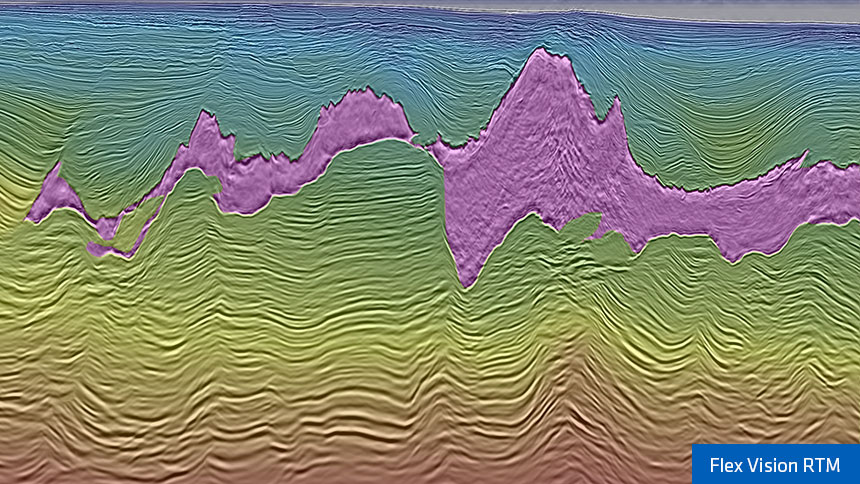
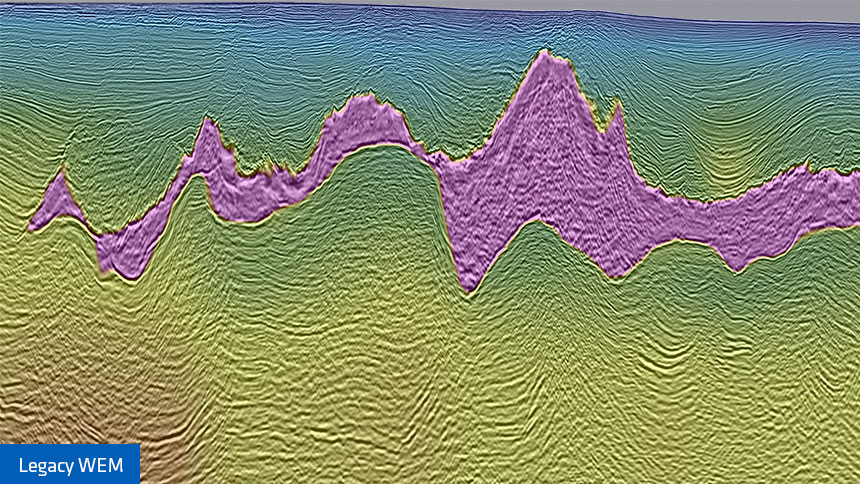
Flex Vision provides tailored images using Kirchhoff for shallower targets, delivering broad frequency content and reliable amplitudes, and RTM for regional understanding and to unlock deeper plays. Due to oilfield infrastructure, new seismic acquisition in the area is difficult and expensive, so rejuvenation of legacy seismic data is a cost effective solution. To exploit nearfield suprasalt reserves, high-resolution seismic images are needed to accurately position existing and new plays. Prolonging the life of subsalt fields, such as Mahogany and Hickory, is only possible by improving models and discovering deeper prospects from superior seismic images such as those offered by Flex Vision.
The data, re-mastered from field tape with full source and receiver deghosting applied, creates a broadband dataset. PGS’ unique dual convolutional and wavefield-modeled surface related demultiple flow uses Separated Wavefield Imaging (SWIM) to both attenuate the complex multiples associated with the Flex Trend and accurately image the shallow water bottom.
A Full Waveform Inversion (FWI) approach was used to build the sediment velocity model. The salt velocity model was built using innovative salt modeling concepts based on a geological understanding of the salt tectonics associated with the extensional-compressional regime characterized by the Roho basins. Based on this concept, salt scenario testing used a lean salt approach, which dramatically improves the subsalt imaging. Following tomography, the subsalt sediment velocities were calibrated using well information. Roho basins kinematically balance up-dip extension and down dip compression along low angle detachments. Individual Roho systems may have different kinematic directions while interfering with neighboring basins and result in complex salt geometries along their fringes. The complexity of salt bodies results from multiple deformation events between salt flow and extensional/compressional movement in the basins. This interpretation revises the role of salt keels replacing massive salt feeders with welded salt delivery systems.
The complex salt geometry was competently handled using an accurate velocity model and Reverse Time Migration (RTM) to reveal structures in the subsalt. Mode converted waves interfere with the imaged subsalt producing sands, and were attenuated by modeling and migrating the mode conversions and adaptively subtracting them from the image. A structural version of the RTM is available for mapping and understanding the deep structures.
Flex Vision delivers a comprehensive and geologically conformable data set in complex salt architecture. The accurate velocity model was used in the migration to produce broadband Kirchhoff prestack depth domain images and a 35 Hz RTM volume. The Kirchhoff data provides a high-resolution shallow section revealing subtle shallow stratigraphic and structural traps as well as shallow gas hazards. The imaging is AVO compliant with available angle stacks and migrated gathers for reservoir characterization. The 35 Hz RTM volume images the Miocene play fairways and potential in the Lower Tertiary. The structural RTM is ideal for mapping sediments terminating against salt walls and determining the structure of the section below 12 000 m, giving regional context and a broad understanding of the structural and depositional framework. Depositional systems transit this 3D volume from north to south, into the prolific hydrocarbon province of the deep water Gulf of Mexico. Flex Vision will cover 30 000 sq. km and will therefore be instrumental in improving understanding of these systems, giving explorers an edge over their competitors.
Please contact a member of our Gulf of Mexico team for more information.