

The trend is clear, oil companies want access to large, high-quality seismic datasets to drive their exploration. To meet this need, PGS is introducing GeoStreamer PURE, a premium product that offers exceptional value for oil companies exploring in mature and frontier areas in northwest Europe.
GeoStreamer PURE represents unified 3D GeoStreamer® depth products, built using the most advanced processing and imaging workflows, to create a suite of exceptional products that carry you through the whole exploration cycle, from regional exploration to detailed reservoir studies.
Since 2009, PGS has acquired more than 100 000 sq. km of GeoStreamer data in key hydrocarbon basins offshore Norway, the UK and Denmark. Most of these surveys are grouped within four key areas in the Barents Sea, Norwegian Sea, Viking Graben and Central Graben. PGS has recently unified these individual surveys into four regional scale GeoStreamer 3D datasets.
Based on many years' experience we have developed a special processing and imaging flow for each of these four areas. The result is a single unified dataset for each area, and quality is guaranteed by using dual-sensor GeoStreamer technology.
As the unified data volumes are comprised of 100% GeoStreamer data, pre-stack deghosting has retained more high and low-frequency signal content. Advanced processing techniques such as PGS SWIM®, Full Waveform Inversion (FWI), and tomography have been used selectively to create a product that supports all stages of the exploration journey.
GeoStreamer PURE is a large-scale MultiClient product that allows customers to explore regional structure, identify leads and plan how to exploit them. Once prospects have been identified, the high fidelity data volumes can be used to derive precise rock properties and provide a better understanding of lithology and fluid distribution.
One of the first GeoStreamer PURE surveys available, from the Viking Graben, covers an area of around 19 000 sq. km. Using FWI, a high-resolution velocity model and depth migration, the effect of the shallow channels and injectites are reduced to produce a robust structural image at all depths. The BCU can be confidently traced, providing a good starting point to chase the Upper Jurassic sands. In the shallower sections, the prestack volumes enable superior definition of the lithology and fluid content of the Paleocene channel and fan systems and injectite play.
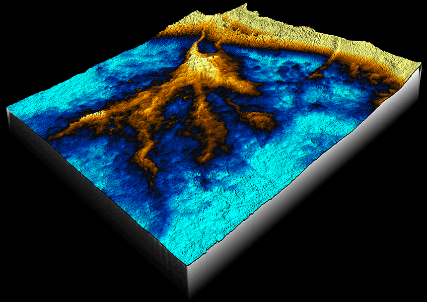 Frigg fan in the Viking Graben viewed from the northeast: the feeder channel and fan lobes are clearly defined enabling high confidence of the overall fan geometry. This structural image is the first step in understanding where there may be any remaining hydrocarbon potential in this well-developed area.
This new flexible and dynamic MultiClient product can be licensed as a whole, or accessed in smaller parts to fit your project requirements. Coverage continues to expand.
To find out more about GeoStreamer PURE Viking Graben, or our other products contact mceurope@pgs.com
#EAGEPARIS2017
Visit us at booth #620 for more information or attend our presentation on Thursday 'Triassic Regional Rock Physics Study in the Eastern Barents Sea for Prospectivity Analysis' (room C2) to see examples from GeoStreamer PURE in the Barents Sea.
Contact a PGS expert
Please contact a member of our AMME team for more information.