

Innovative seismic method improves the process of preparing drilling sites. There is also a benefit for the environment.
Thanks to the inventive use of existing 3D GeoStreamer data, operators can save both time and money, while achieving a result that is technically better than a conventional 2D seismic site survey.
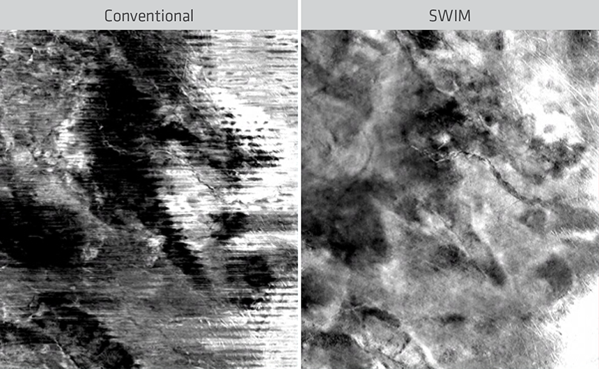
PGS SWIM uses separated wavefield imaging to improve subsurface illumination in shallow water. Reprocessing of existing 3D seismic data provides a better dataset for geohazard analysis.
The operator is responsible for assessing and mitigating hazards before drilling, however, the traditional approach of commissioning a dedicated site survey is time-consuming, expensive and can offer limited coverage. Running SWIM on your 3D volume offers a faster and more flexible method to analyze shallow hazards.
SWIM Benefits
• Separated wavefield imaging (SWIM) is an innovative geophysical solution that harnesses sea-surface seismic reflections to provide better resolution imaging of the shallow subsurface
• Reprocessing is faster than acquiring new data and there are no time-sharing or weather issues
• Shallow hazard evaluation on 3D data allows a broader assessment, including several exploration sites
The objective of a site survey is to identify all possible constraints and hazards from man-made, natural and geological features, which may affect the operational or environmental integrity of a proposed drilling operation. Based on the results, appropriate operational practices can be put in place to mitigate any risks identified (IOGP report number 373-18-1, 2017).
The requirements for a geohazard study are:
• Cover any conceivable well locations
• Provide sufficient data to analyze possible top-hole drilling hazards
• Data quality directly related to the actual conditions expected in the area of interest
In shallow water (< 250 m), this means a separate site survey dataset might be needed, as conventionally acquired seismic data may not have the required illumination or angular diversity in which to perform an appropriate analysis.
Proven Results
One operator who used the solution in 2018 was able to drill the same year, instead of waiting until the next season.
- We optimized the site survey program to a minimum, without reducing the quality requirements. While we were gathering information on, among other things, where on the seabed there were good anchor points, we also collected a limited 2D program to quality control the results. Next time we do it, that will probably not be necessary, says the exploration manager.
- Technically, the data quality more than met all the requirements. We managed to cover a broad frequency spectrum, and we also got a much better velocity field so that both the depth conversion and the fault definition became considerably better.
Having access to a 3D cube, rather than just some 2D lines, makes mapping of anomalies easier and more reliable.
Not only is the solution a better foundation for seismic evaluation, it’s also good news environmentally as there is less in-sea activity. Faster turnaround has additional benefits from a project perspective, as it reduces potential time-sharing conflicts with fisheries in busy areas.
In shallow-water environments, SWIM enables the resolution needed to meet the international guidelines for site survey data quality and it can be applied on all data that can provide separated wavefields. It allows operators to use their existing data to create survey-wide datasets for shallow hazard analysis, bypassing the time-consuming process of acquiring expensive and geographically limited boutique site surveys.
Contact a PGS expert
If you have a question related to our Imaging & Characterization services or would like to request a quotation, please get in touch.