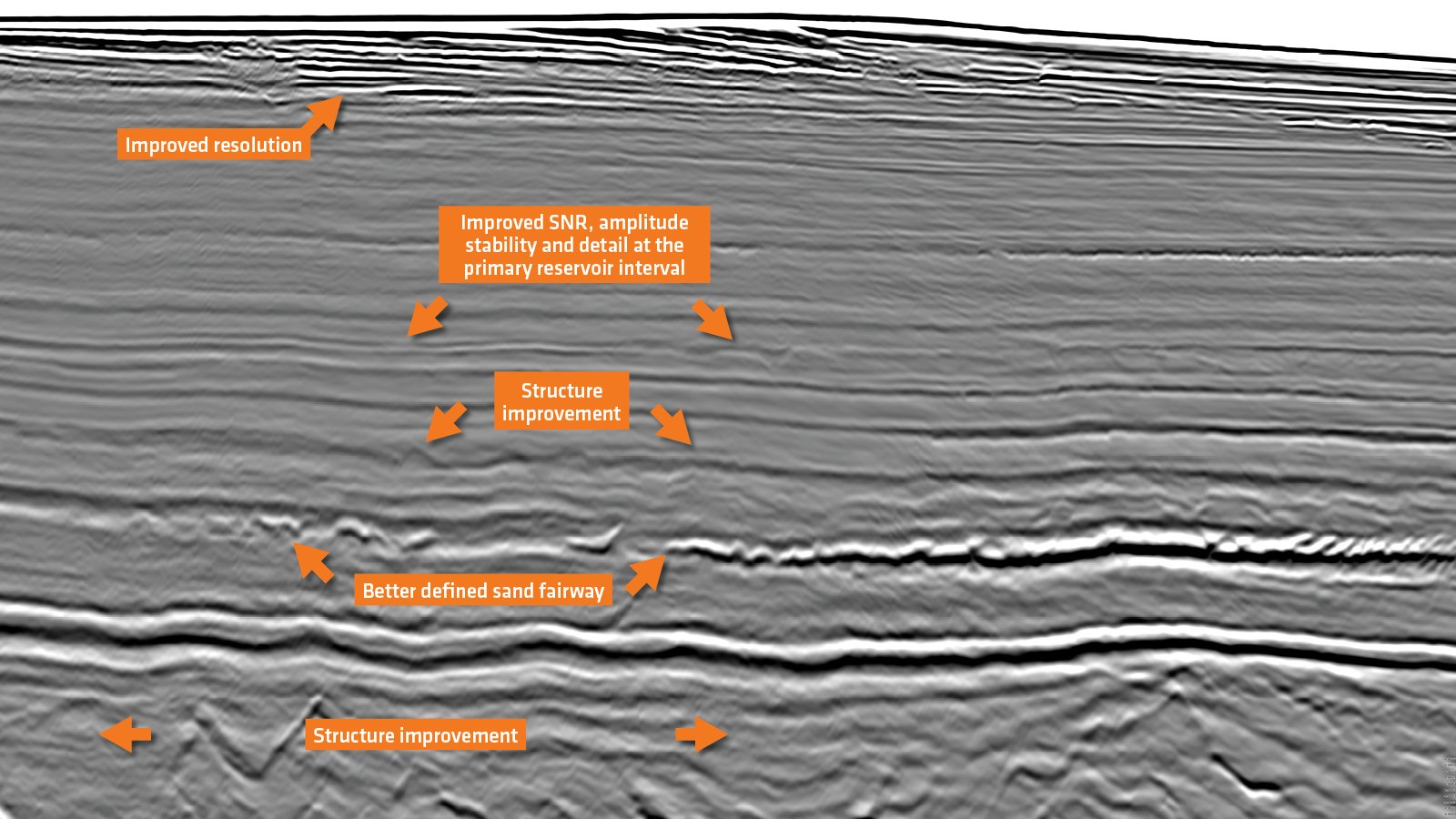
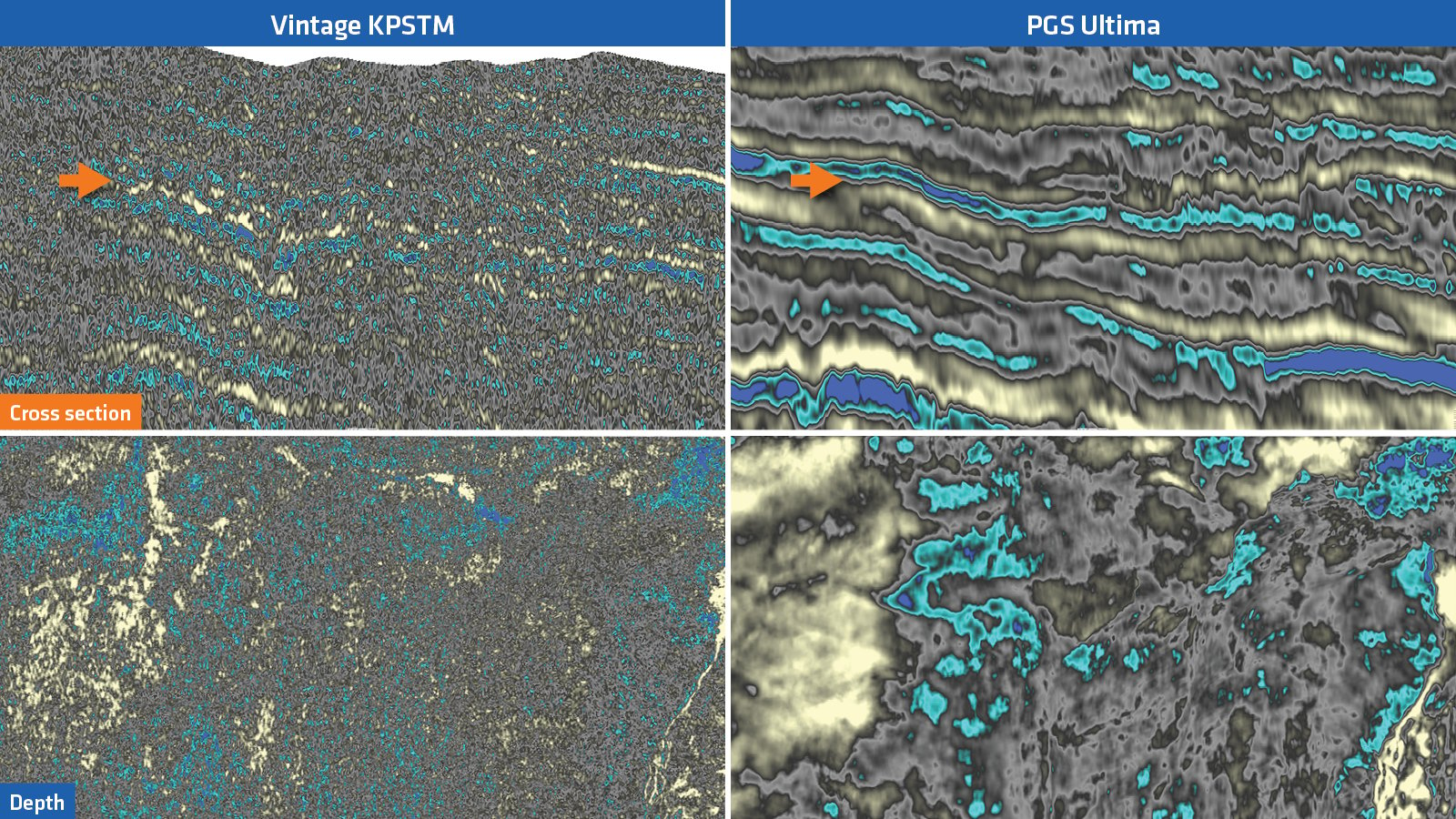
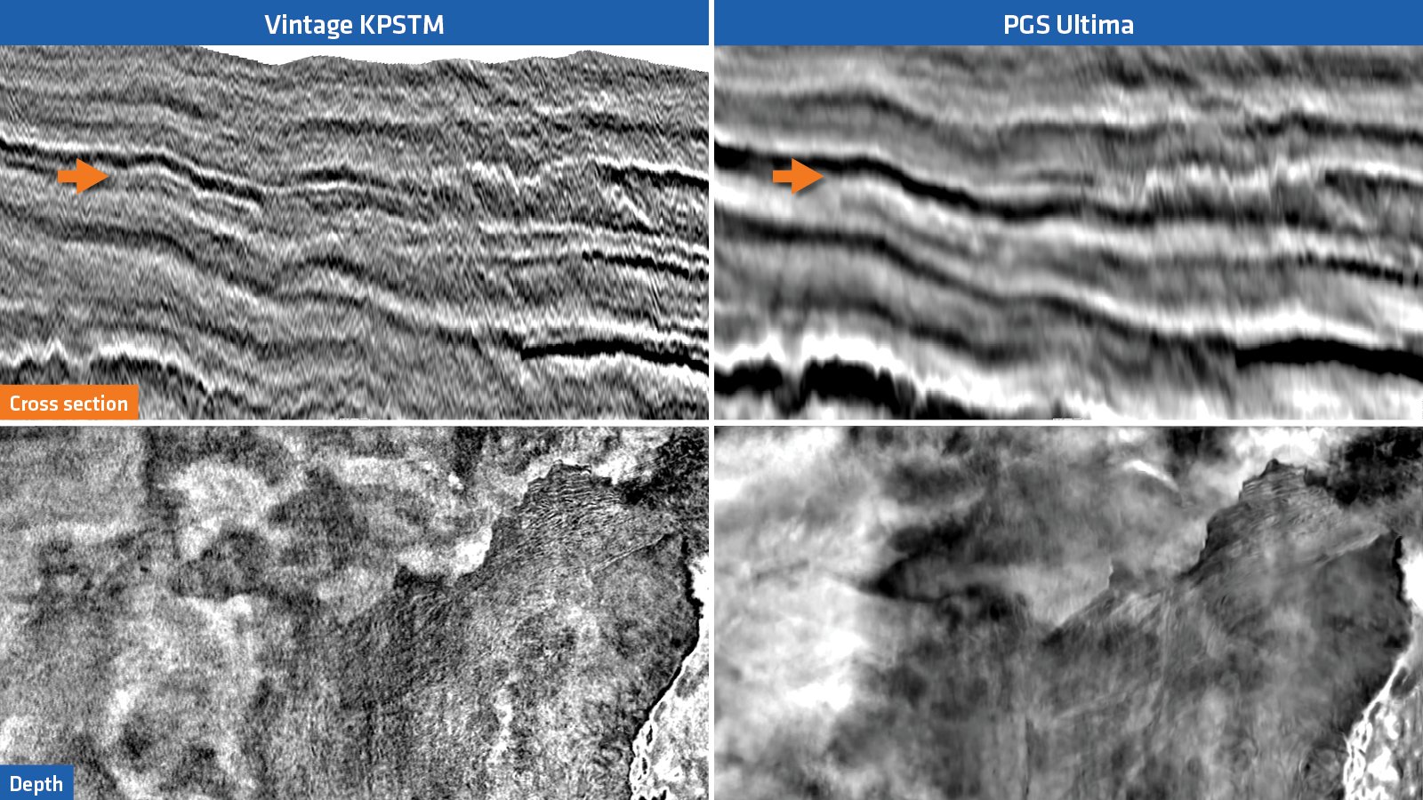
PGS Ultima for Reliable Earth Properties

PGS Ultima for Reliable Earth Properties

Orphan Basin, Canada

PGS Ultima simultaneously delivers direct estimates of subsurface velocity, reflectivity, and their derivatives relative impedance and relative density.   

Location

Location
Orphan Basin, Newfoundland and Labrador
Survey
Blomidon
Survey year
2020
Survey Type
3D GeoStreamer
Configuration
16 streamers x 100 m x 8 km
Survey Size
3 526 sq. km

PGS, in partnership with TGS, has been acquiring modern 3D GeoStreamer data offshore Newfoundland and Labrador since 2015. The availability of such data has been a critical component in the success of the Call for Bids from 2015 through 2020. Access to 3D data provides confidence when bidding on prize blocks and the use of high-end technology shortens the time to first drill and potentially first oil. The PGS/TGS data library comprises approximately 35 000 sq. km of 3D data in the Eastern Newfoundland region defined under the Land Tenure System. The Call for Bids in this area closes in November 2022. High-end imaging technology, like PGS Ultima, and quantitative interpretation workflows clearly demonstrate significant prospectivity in the region, and particularly in the underexplored Orphan Basin. 

Challenge

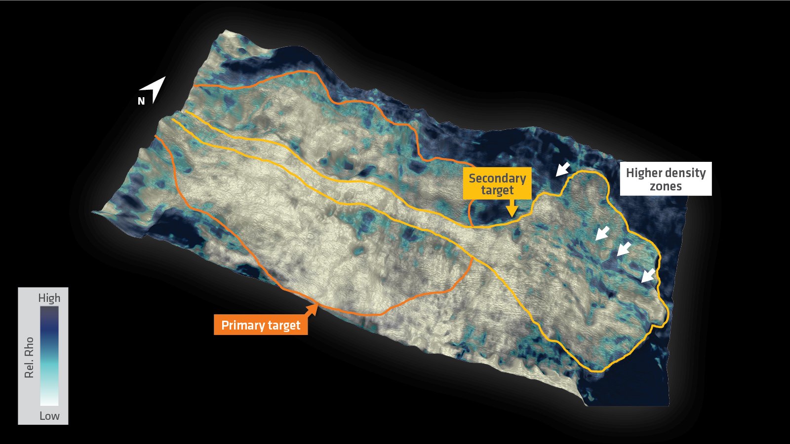
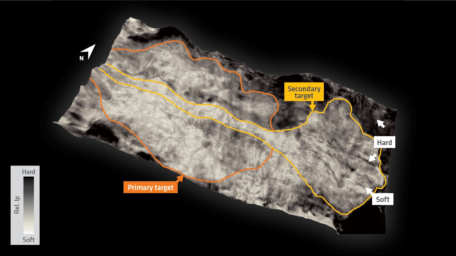
Large-scale Paleogene marine fan systems align along the shelf margin off the northeast coast of Newfoundland. The shallow water, multiples and velocity contrasts in the upper section are the main challenges for derisking the main lead (yellow ellipse). The uplift from PGS Ultima improves the understanding of such prospects within the Blomidon survey. 

Solution

Data
Broadband 3D GeoStreamer
Processing
AVO/AVA compliant
Model building
Reflection tomography and PGS Ultima
Imaging
Kirchhoff and PGS Ultima
Reservoir characterization
Integrated quantitative interpretation

In a traditional sequential imaging workflow, velocity and reflectivity are inverted separately. Exploration teams must wait until the end of the data processing phase to be able to generate a density attribute from the data. PGS Ultima implements Full Waveform Inversion (FWI) and Least Squares Migration (LSM) in a joint scheme and updates both velocity and reflectivity simultaneously at each iteration. It is a data-driven approach and can be run very quickly to deliver direct estimates of the subsurface velocity, reflectivity, and their derivatives, e.g., relative impedance and relative density.

Reliable Structures, Balanced Amplitudes and Improved Reservoir Definition

RTM with Initial Model
PGS Ultima

PGS Ultima requires minimal pre-processing of the input data and can be run very quickly, enabling the technical teams to perform prospectivity and lead assessments ahead of exploration bidding rounds. Improved structural resolution, signal-to-noise ratio, suppressed multiples, and better reservoir definition provide confidence to the interpreters.

PGS Ultima Delivers Better Event Continuity and Image Sharpness

Relative Impedance
Relative Density

Scroll left and right to view these relative impedance and density images (KPSTM on the left and PGS Ultima on the right of each). They illustrate critical elastic parameters needed for reservoir understanding and the significant uplift of the simultaneous inversion. The left-hand-side of the relative density image (right) has been obtained by a comprehensive pre-stack simultaneous inversion using ultra-far stack angle stack whereas the density on the right-hand-side is an efficient by-product of the PGS Ultima inversion. The improvements are clearly seen in terms of signal-to-noise ratio, seismic event continuity, and image sharpness.


Mitigating Exploration Risks Through an Improved Reservoir Assessment with PGS Ultima

Relative Impedance
Relative Density

The left image is the relative impedance property extracted right at the reservoir interval. There are two potential reservoir features shown on the map. Both are notionally interpreted as marine fans. The primary target is shown with an orange outline. The second fan (yellow) is positioned further in the distal part of the map. Since it overlaps with the primary fan and widens the potential reservoir area it was necessary to assess it carefully for possible risks. An overlay of the density and the relative impedance is shown on the right. The secondary fan demonstrates a break in relative density, signaling a change in the reservoir property or a fluid change.

Results

PGS Ultima is a good solution when time is critical, for example, if processing overlaps with a bid round schedule and puts exploration teams under pressure to meet deadlines. It is a fast data-driven approach that delivers direct estimates of the subsurface velocity, reflectivity, and their derivatives, e.g., relative impedance and relative density. Depending on the geological setting and the target level, it can start from minimal pre-processed input data and can be run very effectively, enabling the technical teams to perform prospectivity and risk assessments in a shorter time frame. 

Find Out More

Talk to our experts, select one or more options