

Versatile 3D seismic imaging to meet new energy demands starts with record-breaking acquisition solutions. A combination of wide-tow multi-source spreads and high-density multisensor streamer configurations enables accurate imaging from very shallow targets to deep geological structures.
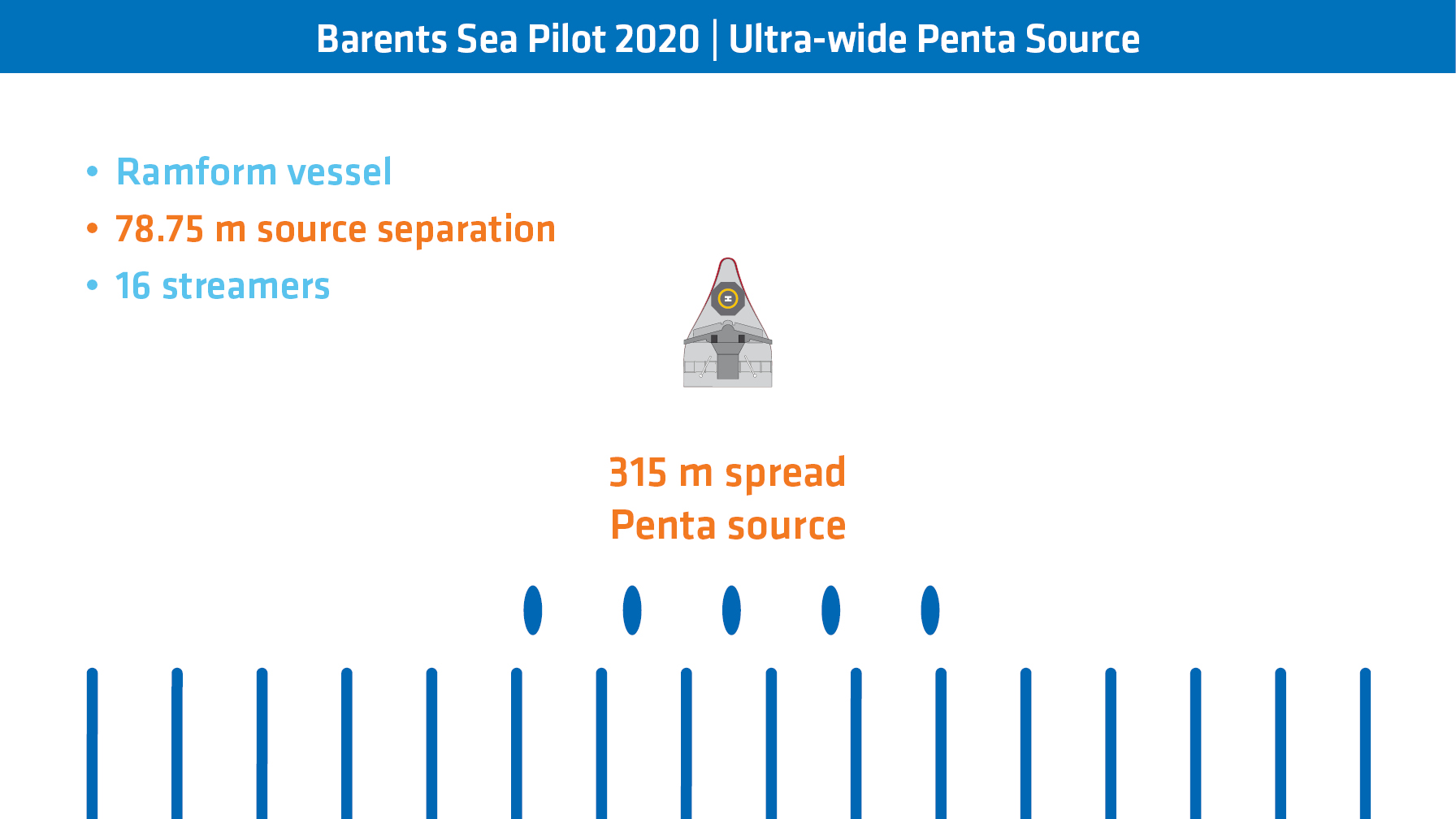
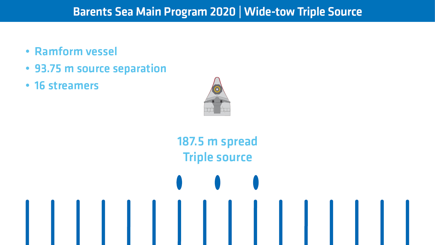
After the completion of a large multi-client 3D program in the Barents Sea in 2020, the survey was extended following a reconfiguration from a wide-tow triple source to an ultra-wide penta source setup (see slider below). Building on the operational experience and the imaging success, PGS took the next leap in 2021 to an ultra-wide hexa source setup – the widest source spread ever towed.
- Read a longer version of this article, published in First Break November 2021
- Read more in Source Flexibility for Efficiency and Improved Seismic Images
Ultra-near offset coverage with wide-tow multi-source configurations
This nearest offset class is seldom populated in traditional towed streamer surveys where a narrow source setup is positioned in front of the two center streamers. The well-known consequences are imaging footprints, most obvious at shallow depths. Wide-tow configurations demonstrate key benefits that overcome the typical challenges faced by traditional streamer surveys, including
- The near-offset coverage can be improved by spreading out multiple sources without sacrificing efficiency (and without increasing survey cost)
- Wide-tow sources enable higher streamer counts than traditional towed streamer setups, and thus higher survey efficiency, without comprising the near-offset coverage
- Rich near-offset coverage benefits both imaging workflows and seismic products, producing less acquisition footprint, i.e. fewer imaging gaps, which is critical for accurately delineating prospects and conducting AVO studies
Imaging of the ultra-wide penta-source data from the Barents Sea resulted in very high-resolution images of the near-surface despite the challenges of the area – a rough seabed with very high impedance contrasts overlaying complex and strong reflectivity. The images are free from any acquisition footprint due to the uniform near-offset coverage made possible by the wider tow of multi-sources.
The near-offset coverage map below illustrates the gain in ultra-near offset coverage achieved with the respective wide-tow triple and penta-source configurations. The ultra-wide penta-source solution demonstrates excellent coverage which is free of near-offset gaps between sail lines.
Near offset coverage map for the 0-100 m offset class from two adjacent surveys in the Barents Sea. While wide-tow triple source provided good ultra-near offset coverage (left), the penta-source solution delivered almost uniform near-offset sampling without the typical gaps at the sail line boundaries (right).
Flexible Acquisition Configurations are Applicable to the New Energy Market
Wide-tow multi-source survey design principles can be adapted for applications in the new energy market, especially for seismic imaging and characterization of the shallow subsurface.
The novel configuration that was piloted in the Barents Sea in 2020 (16 x 56.25 m x 7000 m deep-tow multi-sensor streamer spread) was designed for hydrocarbon exploration. The same survey design principles can be applied to specialized near-surface high-resolution 3D studies such as CCS site characterization, deep-sea mineral exploration, or offshore wind farm site surveying. However, less streamer inventory may be required for these applications.
Near offset, long offset, and 3D spatial sampling requirements will depend on water depth and resolution requirements. Dense streamer spreads with short cables can be complemented with longer tails if refracted waves are analyzed as part of the geophysical studies, and if velocity building or quantitative interpretation (QI) requires access to longer offsets.
The wide-tow sources ensure improved or even uniform sampling of the near offsets in the crossline direction. As near-surface seismic or seabed mapping frequently requires the recording of seismic data with close-to-zero offset, the inline distance between sources and streamers can be minimized by moving the sources over the front end of the streamer spread. The sail-line separation would still be several hundred meters and thus the survey efficiency would be comparable to that used for hydrocarbon applications.
Another potential benefit comes from the deep towing of multisensor streamers. Typically, solutions for site surveys and near-surface seismic are based on hydrophone-only streamers that are towed very shallow, i.e. only a few meters below the sea surface. While the shallow tow mitigates the receiver ghost problem at high frequencies (but at the expense of weaker low frequencies), data quality may be poor, and the operations are exposed to weather downtime. With multisensor streamers, the receiver ghost problem is solved at all frequencies by combining pressure and particle motion recordings. This means the streamers can be towed deep (e.g. at 25 m) and rough sea surface effects are avoided, which results in less noise and an increased operational weather window.
From wide-tow penta source to ultra-wide hexa-source
In the summer of 2021, the PGS operations team was challenged to take this configuration one step further, with an ultra-wide hexa source, deploying a 437.5 m total source spread with 87.5 m source separation, during an exploration survey for Lundin and partners in the Barents Sea.
While towing and handling complexity increases with the number of streamers and sources towed from the same vessel, operating multi-sources from a dedicated source vessel permits more flexible source towing solutions, and thus enables larger source spreads.
The source vessel operated on top of a massive, high-density multisensor streamer spread (18 x 75 m x 8000 m), and simultaneously over a sparse grid of ocean bottom nodes. The record-breaking wide-tow multi-source configuration came with a nominal bin size of 6.25 m x 6.25 m, an (almost) uniform high trace density in the close-to-zero offsets class, and boosted the acquisition turnaround by allowing a sail line separation of 600 m.
Further development of smart and cost-effective seismic solutions continues and includes specialized, tailor-made solutions following the same survey design principles.
#Fleet2Beat GeoStreamer Hexa Source
Contact a PGS expert
If you have a question related to our Marine Acquisition services or would like to request a quotation, please get in touch.