

PGS and SNPC reprocessing over the shelfal area provides robust datasets that reduce the technical risks of Congo shelf exploration. First data available now.
The 2016 Congo License Round blocks have been offered in two phases. Phase I blocks are in the process of being awarded, while the recently opened Phase II focuses on shallow-water shelf blocks, together with remaining deepwater open acreage (see below).
The Congo Shelf presents presalt plays and rift structures in prolific shallow-water acreage, close to existing infrastructure. Mesozoic salt basins with associated fields and discoveries extend across this area to the present-day onshore.
With a modern reprocessing flow PGS and SNPC have revitalized the entire basin area with an improved and consistent regional geological perspective, tying wells to a common 3D data set to allow a regional interpretation and identification of prospects, plays and migration paths.
The Congo MegaSurveyPlus comprises 12 surveys, all reprocessed from field data using the latest broadband processing techniques, to deliver PSDM and prestack volumes and clearer images. Increased bandwidth and signal fidelity allow for better velocity models and more reliable images.
Key Features
- All 12 input surveys are reprocessed from field data
- Both the source and receiver ghosts have been fully attenuated
- Advanced noise attenuation techniques and a targeted 3D shallow water demultiple sequence
- All surveys are matched and merged prior to migration providing a seamless depth-migrated volume
- Broadband frequency enhancement is guided by multisensor GeoStreamer data
- Refraction tomography is used where offset ranges are too short to capture shallow carbonate velocities
- A regional velocity trend has been derived from modern surveys acquired with longer offsets
- Salt velocities are varied with depth and salt type
- Velocity models have been built using well log data
The reprocessed dataset will be available as final PSDM and RTM volumes, together with angle stacks and velocity models.
Deliverables
- Final Kirchhoff PSDM stack
- Final RTM PSDM stack
- Final Kirchhoff PSDM angle stacks
- Raw Beam PSDM stack
- Velocity model
MegaSurveyPlus Phase I is available now with Phase II available from May 2019 and Phase III from June 2019. Preferential rates will apply for pre-commitment.
Find Out More
For further information about prefunding options or to arrange a datashow, contact amme.info@pgs.com


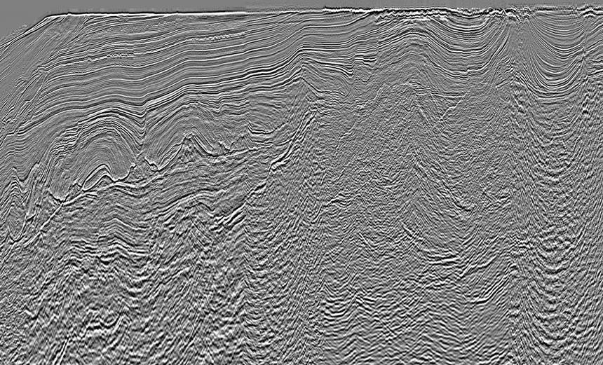
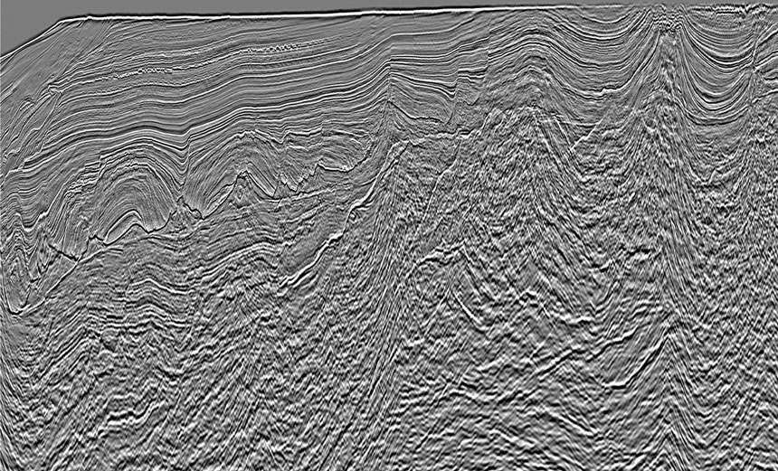
A comparison of MegaSurvey (left image) with MegaSurveyPlus (right image) in the area of MS+ Phase I.
Contact a PGS expert
Please contact a member of our AMME team for more information.