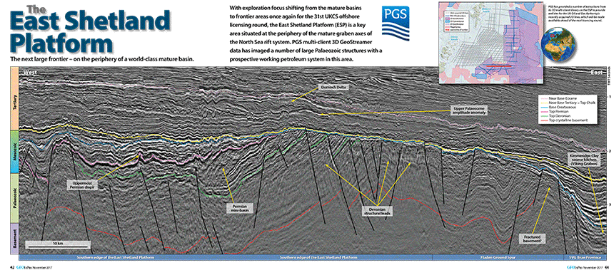
Exploration focus is shifting once again from the mature basins to frontier areas for the 31st UKCS offshore licensing round, making the East Shetland Platform (ESP) a key area, due to its situation at the periphery of the mature graben axes of the North Sea rift system.
PGS has imaged a number of large Paleozoic structures with a prospective working petroleum system in this area.
ESP Vision
The potential of the area was first revealed by 3D GeoStreamer acquisition. A team of PGS geoscientists has been studying the ESP since 2014. Their results have transformed the traditional view of the ESP from an uninspiring high with a shallow basement, to a potential frontier hotspot.
Results produced by GeoStreamer 3D broadband technology over ESP were striking, illuminating Paleozoic structures in areas where several legacy 3D seismic surveys had shown no discernible sub-BCU reflectors.
The first PGS Paleozoic prospectivity interpretation of the ESP MultiClient dataset was completed in 2014. Further analysis, carried out in 2015-2016, revealed potential sub-BCU plays.
Newly-identified elements that may profoundly impact the ESP prospectivity include intra-platform depocenters, such as the one that Patruno and his team baptized 'Crawford-Skipper Basin'.
ESP Awareness
Awareness of the untapped potential of the ESP began to spread, thanks to PGS marketing efforts at conferences, and numerous webinars, publications and client presentations. Interest in the genuine new insights brought to this area could be measured in sales of seismic data and lead to the acquisition of additional 3D GeoStreamer data (2015-2016). It also encouraged the UK Oil and Gas Authority (OGA) to include the ESP in the 29th UKCS Frontier Licensing Round.
In the 31st UKCS offshore licensing round, the East Shetland Platform (ESP) is regarded as a key area.
ESP Interpretation
In 2016 the UK government funded a new 2D GeoStreamer ESP survey, and in 2017 PGS carried out a reservoir interpretation project for the OGA using the new data. Deliverables included a G&G report, horizon and fault files and eight interactive geoseismic profiles.
New elements added to the regional prospectivity assessment, include a successful quantitative interpretation of rocks as old as Devonian (420-350 million years ago). High-correlation well-ties highlight the reliability of GeoStreamer prestack data, even in the Paleozoic. Moreover, a tight correlation is shown between relative acoustic impedance and Upper Devonian effective porosity, with surprisingly high values (5-22%).
Both the interpretation package and the associated survey data were released by the OGA in December 2017. PGS has provided a number of extractions from its 3D multi-client library on the ESP with well-ties for the UK OGA’s recently acquired 2D lines, which will be made available ahead of the next licensing round.

Contact a PGS expert
Please contact a member of our Europe team for more information.