

The November issue of First Break highlights a new multi-azimuth streamer acquisition solution. GeoStreamer X challenges existing multi-azimuth solutions, including OBS surveys, as it delivers a higher-quality dataset at a fraction of the cost and reduced environmental impact.
- Read the full paper ‘Revealing new opportunities with a cost-effective towed-streamer MAZ solution in the South Viking Graben, Norway’
- Find out more about GeoStreamer X
- Check out our Viking Graben data library
An Integrated Acquisition and Imaging Solution
In the autumn of 2019, a novel towed-streamer multi-azimuth (MAZ) acquisition and imaging concept, referred to as GeoStreamer X, was launched with the ambition to challenge seabed solutions by significantly reducing overall costs and turnaround, as well as to deliver the highest achievable imaging quality for interpretation that may be obtained using one or more alternative solutions.
The benefit of an integrated acquisition and imaging approach is outlined in the First Break paper which demonstrates how all the survey design elements fall into place at the processing and velocity model building stages, and provide reliable images and pre-stack attributes.
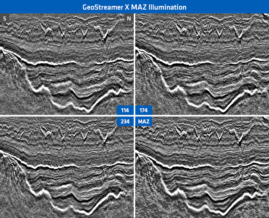
Enhancing Resolution and Illumination with Full Azimuth Imaging
The image below shows how the MAZ stacking process improves reflector continuity, signal-noise-ratio and resolution. The display illustrates Eocene injectites at the top, underlain by an isopachous Paleocene section and the rugose bright top Chalk reflector over the BCU and the deeper Mesozoic rift section down to seismic basement. Note the detail of internal reflection configuration within the Paleocene and pre-Chalk sections as well as the injectite geometries on the MAZ data compared to single azimuth displays. Also, the onlap of the pre-BCU section onto the high on the left is distinct and details of the basement structure are discernable on the MAZ data.
GeoStreamer X Delivering At a Fraction of OBS Cost
The total cost of this solution is considerably lower than that of the present-day estimates for alternative FAZ solutions (for example an ocean bottom seismic survey) while the turnaround is on par with the one expected of a standard single azimuth 3D towed-streamer acquisition and imaging project.
GeoStreamer X uses absolutely all of the recorded information to produce a more complete picture of the subsurface both in the post-stack and pre-stack domains. The integration of the survey design study with the acquisition operations and the imaging technology has shown great flexibility in rapidly providing a fit-for-purpose solution, which we believe can be efficiently adapted to meet challenges in different geological areas.
Contact a PGS expert
Please contact a member of our Europe team for more information.