The Ceduna Sub-basin in Australia’s southern margin offers an untapped opportunity for significant petroleum resource as part of the global exploration portfolio. Analogous to the prolific Niger delta in both size and structural style, this highly-extensional province contains up to 15 km of largely untested post-rift sediments including two widespread Late Cretaceous deltas linked to world-class oil-prone marine Cretaceous source rocks.
Two large 3D seismic volumes, the GeoStreamer® Springboard MC3D survey and the conventional Ceduna 3D survey have been processed as a seamless 20 000 sq.km PSDM volume to become the largest depth imaging product anywhere in the basin. The impact of the depth migration sequence on both the Ceduna subsurface image and structural prospect validity (especially within the White Pointer supersequence) is significant to developing a credible trap story.
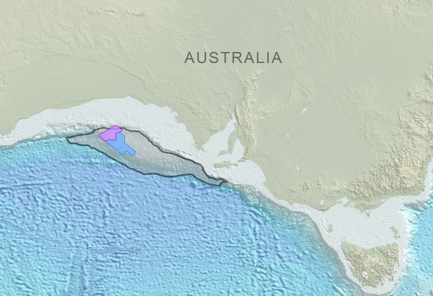
 Springboard 3D GeoStreamer (purple) and Ceduna 3D (blue) surveys within the Ceduna Sub-basin.
Numerous geologic factors posed challenges to the velocity model build and were addressed over six iterations. These include the highly-rugose seafloor, laterally changing velocities within the Tertiary overburden, laterally and vertically amalgamated pockets of shallow potentially high-velocity channels, strongly progradational deltaic shallow marine sandstones, Eocene volcanics, highly-rotated listric growth faults and overpressured shales at the approximate Albian detachment level, which form shale diapirs and produce a basal velocity inversion.
The Springboard PSDM results provide additional information on the structural model, and more specifically, on the nature of faults within the Cretaceous to Tertiary post-rift sedimentary layers. The geometry of listric normal faults above the Albian detachment level is also better resolved after the depth migration. Positioning and focusing of deep linear Jurassic syn-rift faults and basement morphology have also experienced a significant uplift.
Regional interpretation of legacy 2D seismic across the Bight Basin brings the sheer scale and structural complexity of this giant Cretaceous depocentre into perspective, but it is only through the detailed analysis of the GeoStreamer Springboard MC3D survey that its true potential can be quantified. Rigorous phase and amplitude AVO QC of the pre-stack information, coupled with optimized velocity models fed into the depth migration sequence, have ensured amplitude fidelity and phase stability across all offset ranges. This has enabled a systematic and robust exploration workflow of AVO analysis and pre-stack inversion despite limited well data. Numerous GeoStreamer case studies have nevertheless demonstrated these Relative Acoustic Impedance and Vp/Vs volumes to be reliably robust for prospect de-risking because of the extended low-frequency bandwidth.
Frontier screening supported by a partially-automated high-resolution stratigraphic framework has led to the identification of numerous prospects at multiple stratigraphic levels across the survey area. This includes isolation of potentially AVO-supported stratigraphic clinoform plays within the shallow Hammerhead delta, and the extraction of deeper AVO anomalies within the structurally-controlled White Pointer sands draped across large-scale gravity-driven listric fault blocks.
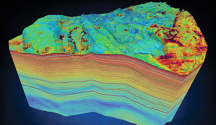
 3D rendering of the Springboard PSDM horizon-constrained tomographic interval velocity model with an RMS extraction of the highly-rugose Ceduna seafloor.