

The May edition of First Break presents a new suite of tools to enable the cost-benefit trade-off between efficient acquisition and image quality to be assessed during a survey planning stage. By using separated wavefield imaging we can provide a better shallow image and by including a full wavefield approach during survey design the most appropriate acquisition setup for a given geological challenge can be determined.
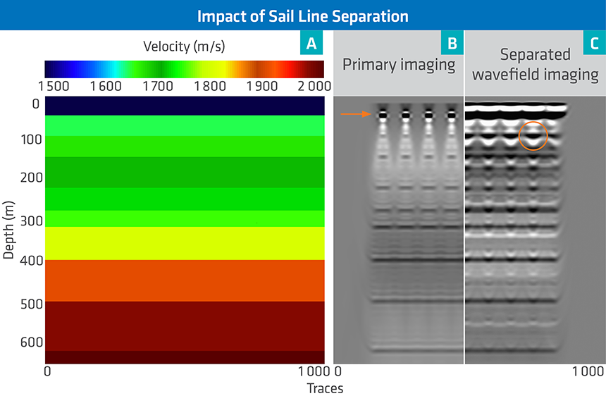
Conventional processing of 3D marine seismic data, based on primary reflections, can suffer from strong acquisition related footprint issues, especially at the water bottom. A better shallow image can be generated by using separated wavefield imaging (SWIM). The article presents a full wavefield approach to provide insight into the optimal acquisition parameters, taking into account imaging of both primaries and sea-surface reflections.
Introducing SWIM at the Survey Design Phase
SWIM is a technique that resolves the acquisition related illumination footprint observed in conventional seismic imaging in shallow water data. However, to benefit fully from the method, the acquisition parameters need to be planned accordingly. Survey planning methods are typically based on ray tracing and consider only primary imaging for reasons of efficiency. Using 1D and 2.5D models, the modeling and migration cost can be reduced, and a full wavefield approach can be applied in survey planning, thereby providing a means to assess challenges specifically related to imaging sea-surface reflections.
Selecting the Optimal Survey Configuration
The full wavefield approach provides a solution to identify and address any potential separated wavefield imaging challenges during the survey planning phase. The depth to which separated wavefield imaging provides an uplift compared to primary imaging can be determined. Once this information is known, the optimal wavefield sampling required to limit image distortion can be estimated.
For practical and efficiency reasons, this optimal wavefield sampling is often too fine to be acquired in the field. However, wavefield resampling prior to migration can be performed and its influence on the final image can be quantified. Based on the survey configuration and the geology, the optimal cable separation that satisfies the imaging requirements after wavefield resampling can now be objectively tested.
Contact a PGS expert
If you have questions related to our business please send us an email.