

PGS is committed to providing the offshore wind industry with a technically and commercially viable ultra-high resolution (UHR) 3D solution at scale. Ground conditions seriously impact wind farm economics and the operational and financial risks can be high.
Having an accurate understanding of seabed and near-surface conditions is key for the development of wind farm locations and we believe that early access to UHR3D seismic data significantly accelerates the creation of a reliable ground model and can minimize risk and reduce cycle time.
30 Years of Marine Geoscience Excellence
PGS was formed in 1991, with the pioneering vision to develop the most efficient 3D operation in the world. In those days, 3D seismic acquisition was done with one or two streamers, a luxury most people couldn’t afford. PGS changed that. In 1993 PGS towed five streamers, in 1996 it was ten, and five years later it was 16, which today is a normal operation.
Over 30 years the number of seismic contractors has risen and fallen. PGS is still here, serving the industry to the highest standards in safety, efficiency and quality. To be here another 30 years from now, PGS must support the energy transition. Our entry into offshore wind is an important part of this effort.
PGS’ 3D wind journey is now underway, with our first commercial ultra-high resolution 3D (UHR3D) survey ongoing. This time we do not start with two streamers. We tow 11 on the first survey and intend to further improve our efficiency as we go.
Offshore Wind in Rapid Growth
Time is of the essence in the fight against climate change, both at the global and societal scale and for each individual windfarm project. At PGS we believe we can help to speed up the development process significantly. We think it is possible to half the time most projects spend on site characterization today.
How can that be done? By providing the right data at the right time.
The PGS ambition is to cut the time spent on site characterization by 50% by providing the right data at the right time.
The PGS solution involves using legacy data if available, as exploration seismic can carry valuable information about near-surface geology if processed correctly. The main step is to map the site at an early stage with ultra-high resolution 3D seismic data, dense enough to be “once and done”. We also aim to acquire all geophysical data in parallel rather than sequentially, preferably all from the same vessel. With proper 3D data a lot of the geophysical interpretation can be simplified and automated. The consolidation of all data and interpretation within a living ground model can now provide actionable insight built on contiguous data rather than interpolated estimates.
The geotechnical program can be optimized to sample all indicated facies and features, instead of oversampling some and overlooking others. With high-quality seismic data available, it should also be possible to refine the quality of synthetic CPTs (cone penetration tests), further reducing the time spent on geotechnical sampling.
Why 3D is required | Complex Near-Surface Geology Requires 3D Imaging
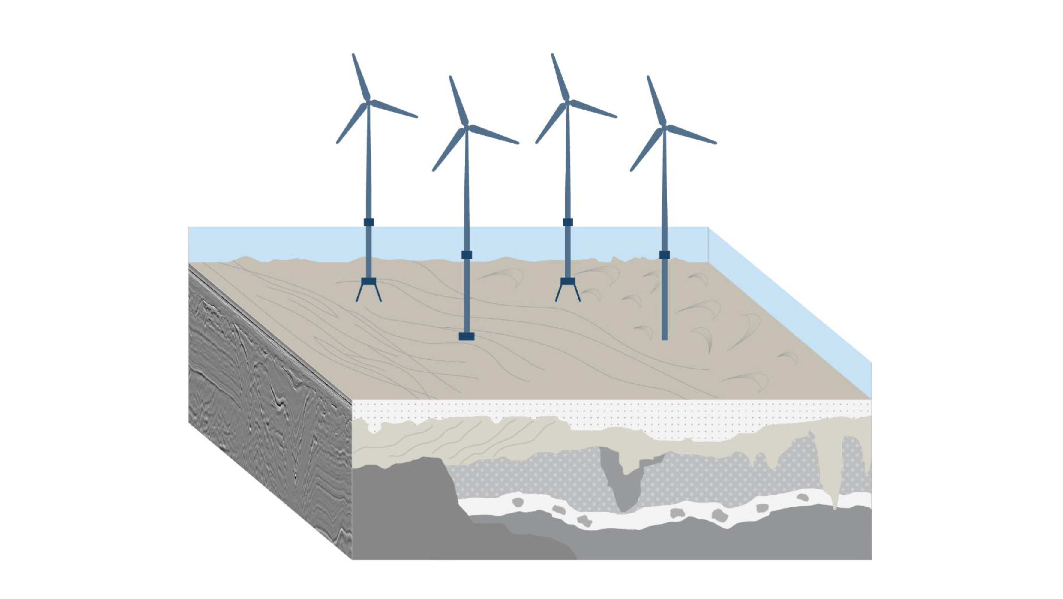
The North Atlantic areas where offshore wind is currently being developed at scale are often dominated by glacial deposits in the near-surface geology. These areas have been through repeated glacial advances and retreats, resulting in rapidly varying and complex soil conditions. Other geographical areas may have distinctly different challenges, like an extremely soft seabed, slope instability or active seismicity.
The foundation solution must be individually evaluated for each turbine location in heterogenous glacial settings like that shown in the illustration below. Monopile may be perfectly adequate in one location but not for the next, or you may have to change the specifications of the monopiles to cater for variations in soil strength. Less standardization means higher cost, and the planned local supplier may not be able to deliver all types of foundations you need. The earlier you know about the specific challenges, the better chance you have of staying on track with the development plan.
The variation in soil conditions obviously occurs in 3D, which means that they cannot be correctly captured with 1D or 2D data. With 2D lines only, it is difficult to determine if the event you see on the seismic line is indeed on the line or a reflection from something to the side of it. The true location can only be determined when you have 3D coverage and use 3D migration.
Complex Geology Requires a Multi-Dimensional Description
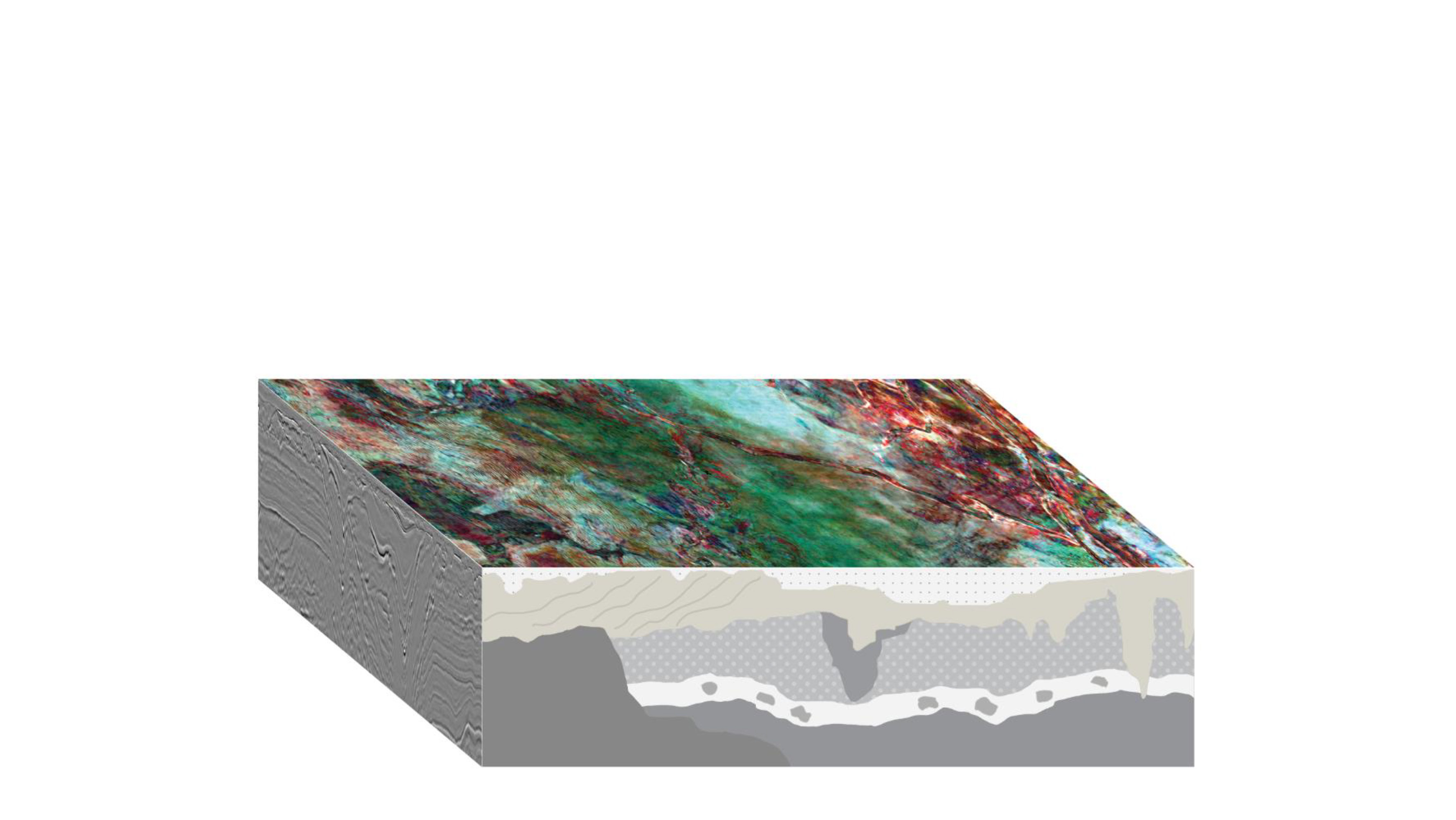
The images below illustrate the value of 3D, the top shows a horizontal slice through a 3D seismic volume, approximately 20 meters below seabed. This is from our MultiClient 3D data library in the North Sea, the data is reprocessed to optimize the resolution for use in offshore wind.
These seismic images are from our 3D MultiClient data library in the North Sea and highlight many geological challenges relevant for windfarm planning. The data has been reprocessed to optimize the resolution for offshore wind. The top one shows a horizontal slice about 20 m below the seabed and the lower panels show vertical sections.
The lower panels show vertical sections through the cube. Because it is a fully populated 3D volume, all of the features seen in the seismic data are accurately positioned and can be isolated as geo-bodies directly from the data without too much human interaction. Those geobodies can then be probed and assigned specific geotechnical parameters.
The ‘ripples’ on the top image (horizontal slice) are likely to be glacitectonic till, sediments pushed and compacted by an expanding ice front. The middle part shows polygonial faults, which indicates a permafrost tundra setting, likely fine grained and clearly with cracks in it. In the northern part of the top image some isolated kettle lakes with unknown fill, perhaps soft clay can be observed. The whole area is cut by a number of large tunnel valleys, created by water flowing under the ice, and within those valleys you can expect rapid variations in soil conditions as they in turn are infilled by younger and smaller channel systems.
There is also a clear indication of shallow gas, a hazard you want to avoid when drilling geotechnical boreholes.
Pioneering Marine Seismic Solutions for Evolving Energy Needs
PGS has more than 30 years of experience with acquiring high-quality 3D seismic data. We have pioneered efficient 3D operations and we were the first to launch and industrialize 3D broadband technology for exploration and production seismic. The illustration below shows examples of our more recent innovative 3D solutions.
Some of PGS' pioneering marine seismic acquisition solutions, suitable for evolving energy needs.
Recently, there has been a lot of focus on cost effective high-resolution seismic for shallow targets. To meet the requirements for spatial sampling and good coverage of the near offsets, PGS has introduced wide-tow multi-source solutions. Wide-tow multi-sources means that we spread out multiple sources in front of dense streamer spreads.
PGS has successfully acquired more than 15 surveys with wide-tow multi-sources during the last three years and has another five on the schedule for this year.
Applications are not only for hydrocarbon exploration, but also more and more development projects for Carbon Capture and Storage (CCS) where imaging of the shallow overburden is important.
The newest member in our solution portfolio is P-cable. We are combining proven concepts from our 3D seismic operations, in this example above, a wide tow triple source with a dense 3D streamer spread. However, we are dealing with a very different scale as we must provide ultra-high-resolution products for the evaluation and development of 3D offshore wind farms.
The drawing of the P-cable is not to scale. The actual scale of a P-cable configuration is much smaller compared to our standard streamer spreads as indicated here with the orange circle.
2D Versus 3D
Traditional 2D site surveys for offshore wind farms involve a reconnaissance phase where development areas for offshore wind farms are typically covered by a grid of ultra-high resolution 2D seismic lines. A grid could consist of 2D lines with 200 m separation in one direction and 2D tie lines with larger spacing (500 m) in the orthogonal direction.
An initial assessment of the area is then followed by a refinement phase where additional 2D infill lines are acquired resulting in a denser grid of 2D lines.
How can we shorten the overall cycle time from initial site evaluation to the installation of turbines, and at the same time provide better data and reduce project risk? The answer is ultra-high-resolution 3D seismic.
Efficient Ultra High-Resolution 3D (UHR3D) Acquisition Solutions
With P-cable technology, it is feasible to cover an entire development area with dense, ultra-high-resolution 3D seismic data in an efficient manner. 3D surveys with bin sizes in the order of 1 m are now a realistic alternative to 2D (middle panel of the graphic below).
An alternative to full 3D coverage is to acquire corridors of ultra-high resolution seismic data. The corridors would be a few 100 m wide and centered around potential turbine locations (left panel below).
A third approach would be to cover an entire development area with 3D data, however by trading off spatial sampling for higher efficiency. In the latter case, the bin size could be in the order of 2-3 m while the efficiency is boosted by a factor of three compared to our first scenario. Initial processing and interpretation of the data could be done while the survey is ongoing and then certain areas identified for a more detailed risk assessment. Additional 3D swathes would then be acquired to achieve locally improved spatial resolution (right panel below).
Options for efficient UHR3D acquisition solutions. Left: acquire corridors of ultra-high resolution seismic data. Middle: cover an entire development area with dense, ultra-high-resolution 3D seismic data in an efficient manner. Right: cover an entire development area with 3D data, during acquisition initial processing and interpretation can identify certain areas for a more detailed risk assessment.
The examples below illustrate what the P-cable configurations look like for the 3D site survey scenarios mentioned above.
On the left side, there are 10 streamers with a separation of 6.25 m. The dense streamer spread is combined with a wide tow triple source. The resulting bin size is in the order of 1 m and the sail-line separation is approximately 30 m.
The example on the right-hand side is a more efficient solution. The number of streamers is 14, the streamer separation is 12.5 m, i.e., it is doubled, and we combine it with a wide-tow quad source. The sail-line separation is now approximately 90 m, and the effective bin size is approximately 3 m.
These examples are for illustration purposes and PGS designs solutions on a project-by-project basis, considering survey objectives, client requirements, and water depth plays an important role.
P-cable configurations for 3D windfarm site surveys. These configuration examples are for illustration purposes only. Final solutions will be tailored depending on survey objectives, client requirements, and water depth.
We have not only more than 30 years of experience with seismic acquisition. PGS has also the expertise, experience, and the technology for processing high-resolution 3D data.
Our advanced processing and imaging toolbox (see illustration below), originally developed for oil and gas, contains all the algorithms and workflows needed to process ultra-high resolution 3D data. It includes pre-processing technologies as designature and deghosting, water column statics, tidal corrections, multiple removal, regularization, and interpolation. Different types of high-end imaging techniques as well as QI are also part of our toolbox.
Migrated early-out 3D or 2½D products can be delivered during a survey, allowing for instant interpretation and decisions about infill lines to be made.
Some of the areas proposed for offshore windfarms are already covered by 3D seismic, originally acquired for hydrocarbon exploration. Reprocessing this data, with a focus on the near-surface, could substitute 2D seismic in the reconnaissance phase.
PGS' high-end processing toolbox unleashes the full potential of UHR3D.
Compress the Site Characterization Timeline Using 3D Data
PGS recognizes the value of detailed subsurface understanding and can deliver efficient and scalable acquisition and imaging to serve the fast-growing offshore wind industry. Enabling you to reduce risk and time to operation with our optimized solutions for ground model generation and geohazard identification.
Contact a PGS expert
If you have questions related to our New Energy business please send us an email.