

Every exploration manager knows estimates are more reliable if they use better data. Multisensor GeoStreamer acquisition provides three key platforms for seismic imaging. PGS advanced imaging solutions take advantage of this to extract reliable attributes.
Key Benefits
- Ultra-low frequency signal in the 2-4 Hz range on raw hydrophone data
- Access to separated wavefields
- Densely-sampled receiver wavefield
GeoStreamer’s calibrated multisensor receivers enable wavefield separation to provide two independent signals. The ghost-free up-going pressure wavefield (‘P-UP’) is a direct reflection from the subsurface, while the down-going pressure wavefield (‘P-DWN’) is reflected from the earth and again from the surface of the ocean. P-UP permits seismic imaging and quantitative interpretation (QI) using the broadest-possible frequency bandwidth. P-DWN provides new opportunities in both imaging and QI.
Deep-towed GeoStreamer gives full waveform inversion (FWI) access to the lowest usable frequencies. We use the full wavefield, enabling deeper models that can be relied on in imaging and which facilitate derisking of prospects.
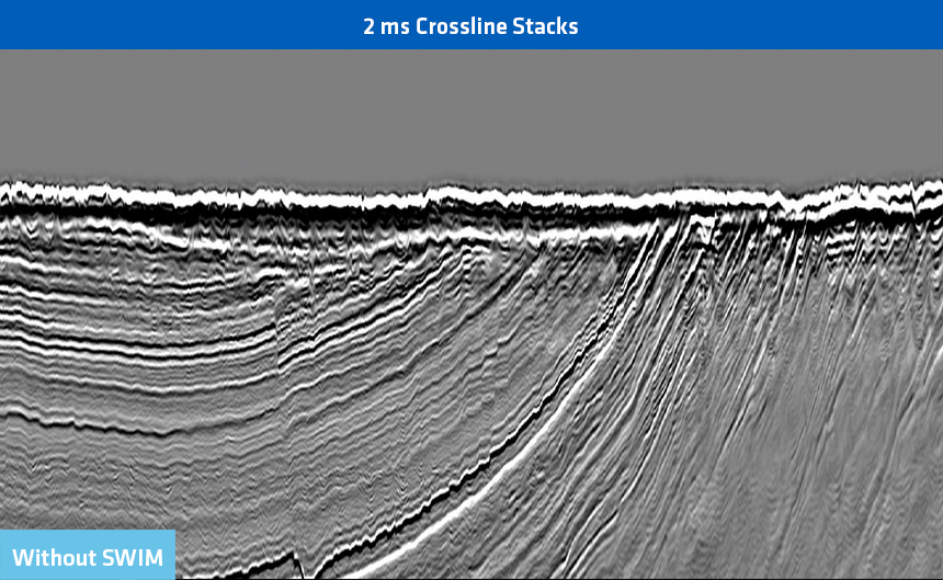
PGS’ separated wavefield imaging (SWIM) uses P-UP and P-DWN to turn each GeoStreamer receiver into a virtual source. Free-surface multiples are exploited to increase illumination during migration. Shallow acquisition footprints are mitigated and shallow resolution is substantially improved.
The PGS least squares migration (LSM) portfolio substantially improves vertical (thin bed) and spatial (dip) resolution at all depths regardless of the underlying imaging algorithm. All our imaging solutions accommodate high-order anisotropy and are viscoacoustic, compensating for attenuation effects.
Power Tools for Deep and Accurate Velocity Updates
PGS’ full wavefield implementation creates deep, high-resolution velocity models regardless of streamer lengths. PGS FWI uses the full wavefield, both reflections and refractions, to produce long wavelength updates. This reduces the traditional dominance of high wavenumbers when reflections are involved in the inversion and creates deep, high-resolution velocity models regardless of streamer lengths. Cycle-skipping effects are avoided thanks to the ultra-low frequency GeoStreamer signal.
The resulting models reduce imaging uncertainty. They can also be used to derive reservoir measurements, eliminating the low-frequency gap that historically penalized AVO-based inversion of elastic properties, and assisting with prospectivity derisking.
Migration Solutions
Beam migration is widely used for rapid velocity model building (VMB). The award-winning PGS hyperBeam system, combined with PGS hyperTomo, enables fast and flexible model building. Numerous models of velocity, anisotropy, and Q can be built simultaneously in the offset and angle domain.
Kirchhoff migration is the most widely-used migration in PGS. It accommodates orthorhombic anisotropy and viscoacoustic pre-stack time and depth migrations. Whilst Kirchhoff migration is robust for most acquisition geometries and earth models, the method makes several fundamental assumptions that break down in increasingly complex geology. In these situation migrated images may be affected by non-uniform illumination, shallow images can be impacted by the acquisition footprint, and spatial resolution may be limited.
Wave theoretic PSDM is a powerful alternative using finite differencing to forward propagate source wavefields, backward propagate receiver wavefields, and apply some form of imaging condition to recover the earth’s reflectivity from the source and receiver wavefields at every point in the recorded dataset. The nature of the finite difference propagator determines what geological complexity may be imaged. No smoothing of the velocity model is required, and implementation is in the depth domain. One-way wave equation migration (WEM) robustly images steep and non-overturned dips, while two-way wave equation migration, also known as reverse time migration (RTM), can image overturned dips. Both the WEM and RTM solutions at PGS are fully anisotropic, viscoacoustic, and produce angle domain common image gathers (ADCIG).
Harnessing Multiples with SWIM
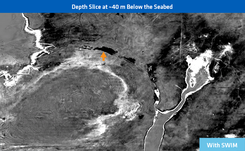
Access to both P-UP and P-DWN means that every GeoStreamer receiver can become a virtual source in PGS’ SWIM solution, providing additional illumination from multiples everywhere in the subsurface. Benefits include mitigation of the shallow acquisition footprint and high-resolution imaging to reveal shallow targets or shallow hazards and optimize shallow velocity model building. Used in conjunction with an extended imaging condition, SWIM can produce ADCIGs to assist AVO classification, creating new opportunities for shallow QI.
Additionally SWIM is also a powerful solution for imaging ocean bottom cable and node data (OBC / OBN), extending the illumination well beyond that of the receiver array.
Full Wavefield Migration (FWM) also exploits the separated wavefields. It makes use of primaries and multiples to extend the capabilities of SWIM, optimizing subsurface illumination and improving image resolution for all depths.


Recovering True Reflectivity with LSM
Least squares migration is an inversion approach that, unlike FWI, updates the reflectivity rather than the velocity model. PGS offers two LSM solutions referred to as ‘targeted’ and ‘global’ LSM. In targeted LSM a multi-dimensional deconvolution de-blurs the already migrated data using Point spread functions (PSFs). PSFs represent the migrated impulse response to point diffractors and are computed throughout the input data volume. In addition to improvements in the recovered reflectivity, spatial resolution is improved (including faults).
In global LSM, the reflectivity of pre-stack data is iteratively updated in a model-migration loop. The input data are migrated; which is then used to model the data. The difference between the acquired and modeled data is used to update the migrated image. This process continues until the residual between the acquired and modeled data is acceptably small. This methodology recovers the true earth reflectivity wherever the velocity model exists.
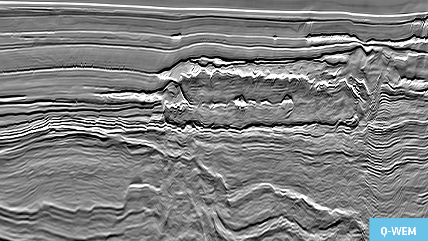
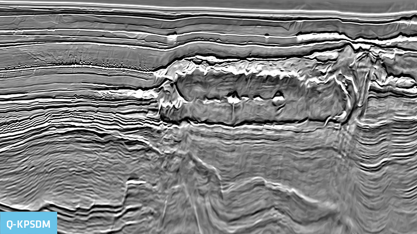
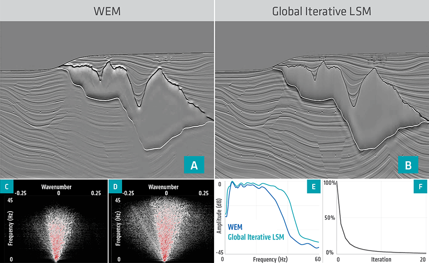 This figure provides a synthetic comparison of sub-salt data imaged with WEM (Migration) and LS-FWM (LSM). Shallow spatial resolution and image quality benefits from the contribution of multiples, deeper shadow zones, and variable illumination are mitigated when using LS-FWM, providing improved deep spatial resolution and image quality improvements too.
A Flexible & Ever-Expanding Portfolio
PGS has a comprehensive suite of imaging solutions that can be tailored for each geological setting. FWI is an increasingly integral component of any imaging workflow. In most scenarios, Q-KPSDM or Q-WEM are perfectly acceptable solutions, but migration algorithms beyond traditional Kirchhoff algorithms are invaluable for more complex challenges.
SWIM offers an increasingly popular and cost-effective imaging alternative to site surveys. Where penetration barriers in the overburden create shadow zones degrading migration focusing and spatial resolution, least squares can be as a solution that serves as the key deliverable. RTM has historically been the mainstay for sub-salt imaging, but viable improvements now include LS-WEM and LS-FWM.
The variety and versatility of the PGS portfolio extend to azimuth-sectored velocity model building and imaging for advanced acquisition geometries, including OBC and OBN. An advanced 4D toolkit enables imaging for conventional, slanted and GeoStreamer data, as well as integrated streamer and OBN processing. PGS also offer AVO inversion and QI projects with targets from the very near-surface to pre-salt depths.
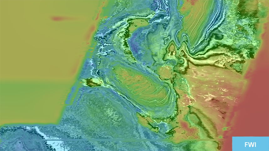
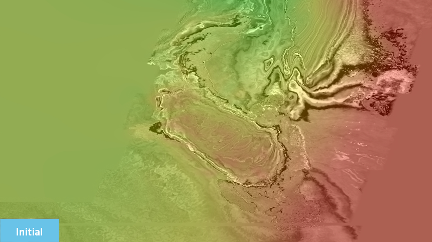
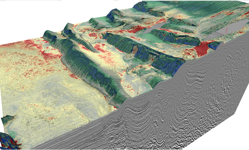 Pre-stack elastic inversion attribute draped over a Q-KPSDM image from complex geology
Contact a PGS expert
If you have a question related to our Imaging & Characterization services or would like to request a quotation, please get in touch.