

GeoStreamer data reveal many remaining nearfield opportunities in the Tertiary injectite super-producing reservoirs of the North Sea. Entirely seismic-driven inversion, combined with rock-physics analysis, derisks injectite-opportunities with excellent correlation to corresponding well data. This indicates that entirely GeoStreamer seismic inversion can reliably characterize reservoir lithologies and derisk hydrocarbon presence potentially without well-input.
PGS has published in the Geological Society of London’s Special Publications describing the image processing and seismic inversion workflow deployed to identify, characterize, and derisk injectite opportunities by integrating high-quality prestack GeoStreamer data with rock physics analysis of well data from fields in the UK and Norway.
Read more about Norwegian injectite opportunities in our Viking Graben case study. New potential in the UK sector is highlighted below.
Key Findings
- New prospective injectite reservoirs are revealed in both the UK and Norwegian sectors of the Viking Graben
- Acoustic impedance (Ip) data must be interpreted alongside reliable velocity ratio data (Vp/Vs) in order to effectively identify sand from shale, and potential hydrocarbon presences from brine fill
- The predictive potential of GeoStreamer seismic inversion can be cost-effective. Good correlation of lithology and fluid property prediction between well and seismic data validates the robustness of the seismic inversion results and suggests injectite opportunities can be independently resolved away from well-input
The Maclure field is located just west of the UK and Norwegian maritime border and is covered by GeoStreamer data.
The Demand for Near-field Opportunities
Injectites, remobilized unconsolidated sands, are commercially attractive targets due to their exceptional porosity-permeability, productivity, and particularly in the case of North Sea Tertiary injectites, their abundance and close proximity to existing field infrastructure. Mature basins declining in production, such as the Viking Graben, need near-field or extended-reach tie-backs above and adjacent to producing reservoirs to supplement production and prolong field life, and injectites offer just that. Even modest-sized injectite features can represent attractive, relatively shallow, near-field objectives.
The challenge has been to discriminate hydrocarbon-filled high porosity-permeability features from tight or dry reservoirs. Conventional band-limited seismic data is too unreliable to accurately image injectite complexity as they are relatively narrow, have enigmatic geometries, and disappointing wells show not all are hydrocarbon-charged. PGS have devised a solution using GeoStreamer to resolve injectites with detailed broadband processing and characterization.
GeoStreamer Enables Robust Seismic Inversion to Reveal Hidden Prospectivity
GeoStreamer delivers a broader seismic bandwidth than conventional ‘band-limited’ methods. Additional high and especially low frequencies (down to 3-4 Hz) result in wavelets with significantly less side-lobe energy. This significantly improves data interpretability as side-lobe energy can present false leads in the form of misleading seismic horizon artifacts. The lower frequencies also introduce more background trend information to the seismic response, allowing clear definition of geological boundaries.
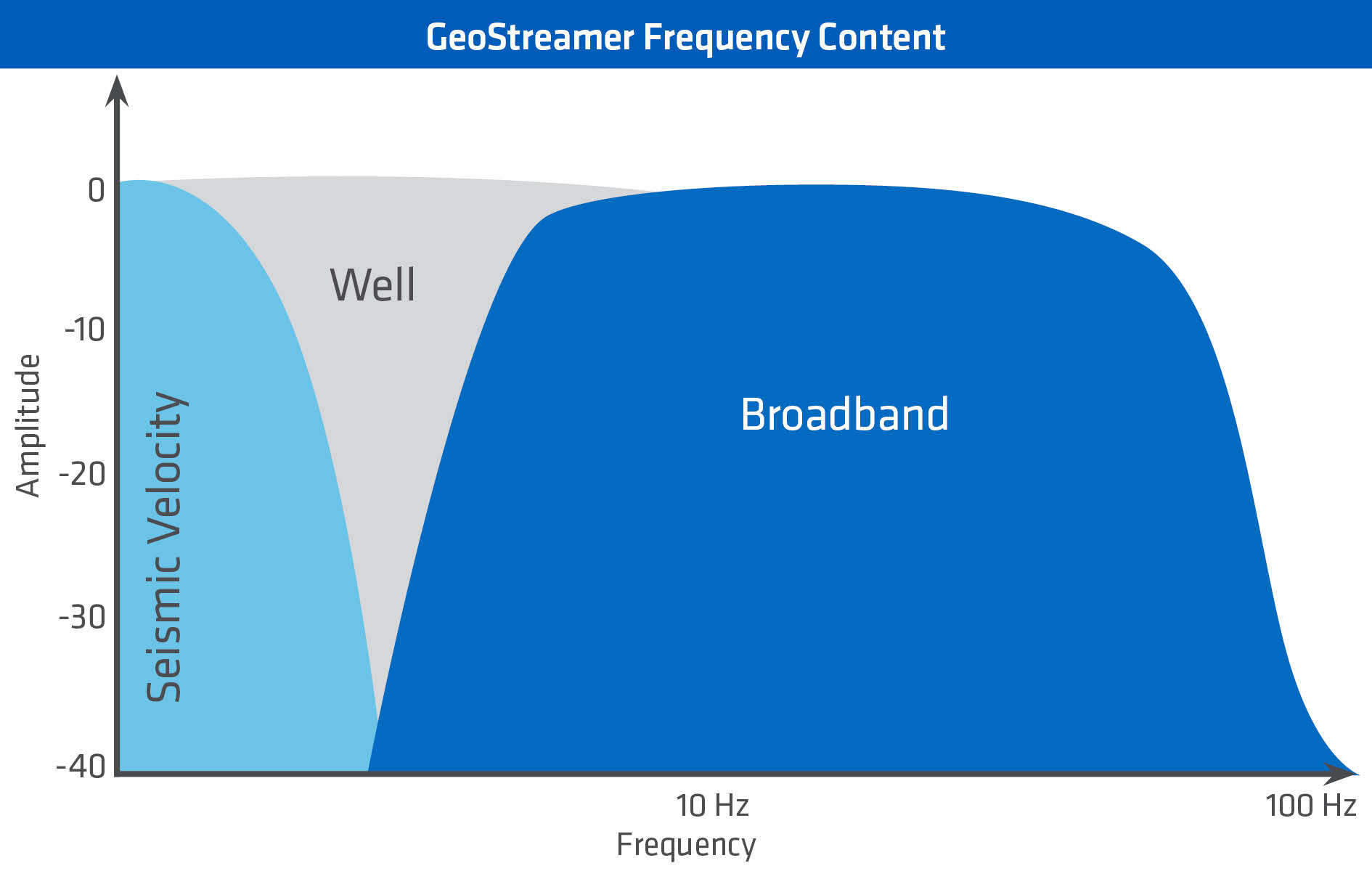
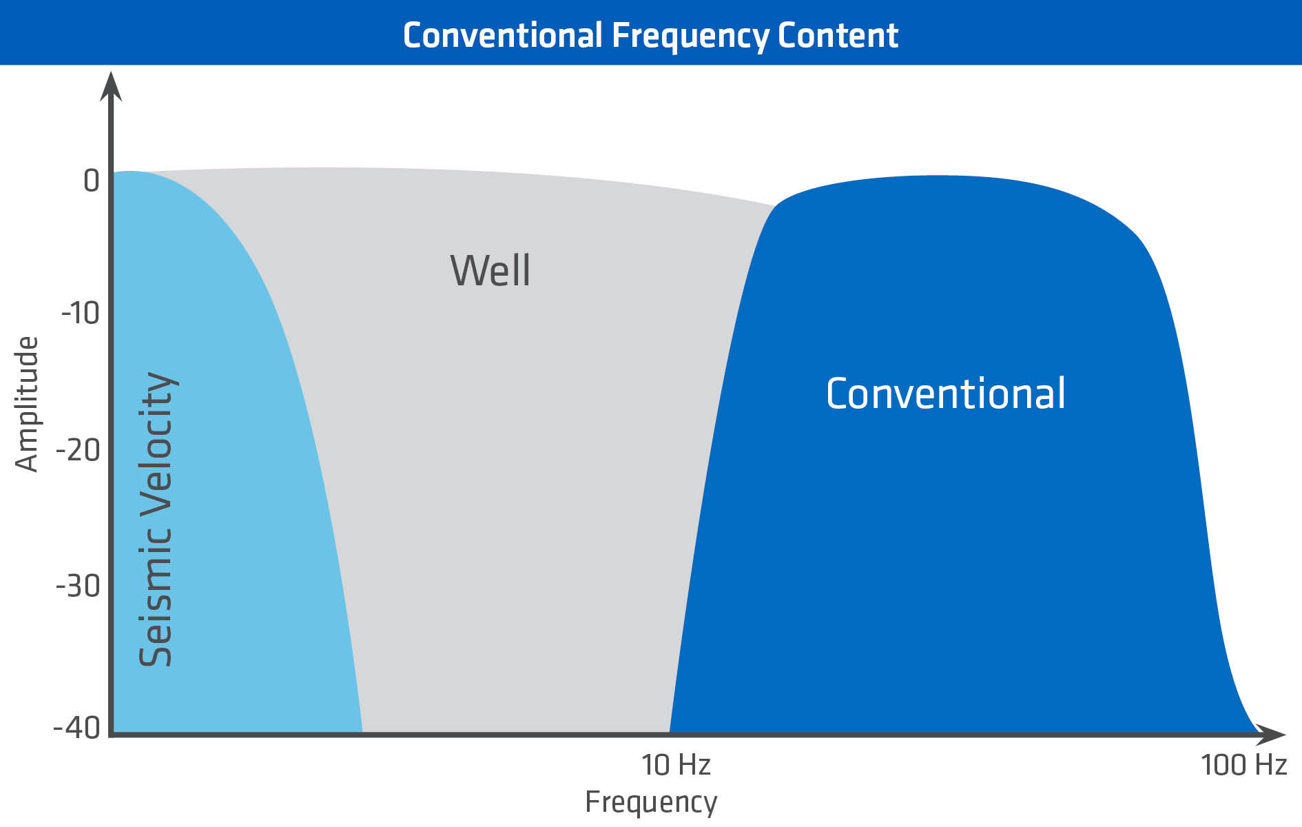
The PGS complete wavefield imaging (CWI) processing workflow includes full wavefield inversion (FWI) and separated wavefield imaging (SWIM) to correct local velocity anomalies associated with shallow geology. More detailed shallow velocity modeling makes for a more superior final image of the underlying features, such as the targeted Paleocene injectites. The dataset below shows the improvements prestack broadband data and PGS image processing can make on mapping injectite geometries. New opportunities east of the Maclure field are revealed with broadband seismic data, but are not apparent using band-limited seismic frequencies.

Revealing Low-risk Exploration Potential
Reliable volumes of acoustic impedance and velocity ratio data using GeoStreamer seismic inversion enable the possibility of 3D lithology and fluid prediction. While derisking potential reservoirs is challenging using only acoustic impedance data, a combination of both acoustic impedance and velocity ratio data can confidently discriminate between different lithologies and fluid classes. A lower velocity ratio is expected for sand reservoirs compared to shale, while low acoustic impedance within the sand reservoir intervals typically indicate hydrocarbon fill.
The slider below shows injectite features near to the Maclure field and 2015 Corona discovery. The lowest velocity ratio values (red) can be confidently characterized as sand lithologies. This is picked out over the relative acoustic impedance data of the same depth section (black outlines), but only the upper portion of the left-hand injectite group has low enough impedance values to suggest hydrocarbon fill, and low-risk exploration potential. By contrast, the other injectite features below and to the right show ambiguous/high impedance response suggesting that there are water-wet sands sitting below the potential hydrocarbon-water contact, and are therefore high-risk exploration targets.


Identifying Hydrocarbon Charge Without Well Input
Rock physics analysis using appropriate key wells from the UK and Norwegian Viking Graben confirms the validity of the inversion results with excellent well ties to the prestack broadband seismic elastic attributes, even though well data have not been used in generating the seismic inversion attributes. Good lithology and fluid discriminations can be expected using elastic attributes, supporting the predictive potential of reliable GeoStreamer seismic as input to elastic inversion.
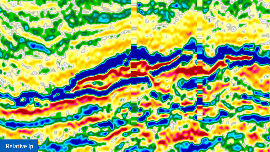
The slider below emphasizes the good tie between relative acoustic impedance from the wells and from the seismic data (left), and the quality of the seismic-derived velocity ratio data attribute for lithology prediction (match between low-velocity ratio and gamma-ray resistivity values) at the injectite intervals.

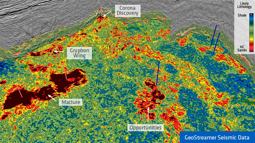
A 3D map view of the area illustrated in the figures above. The dashed line indicates the transect shown in the Ip - Vp/Vs slider. Acoustic impedance values are displayed only where sands are identified by low Vp/Vs seismic attributes. Low impedance values indicate hydrocarbon fill in the Maclure Field, the Corona discovery, and across the dotted line. Other similar features could be derisked in the same way.
Contact a PGS expert
Please contact a member of our Europe team for more information.