

A new GeoStreamer X early-out product is available now and provides high-resolution data to resolve imaging challenges in the Norwegian Sea, revealing remaining potential and derisking future drilling opportunities.
For more than 10 years, PGS has built a comprehensive and contiguous data library in the Norwegian Sea. A wide range of technologies and workflows have been employed to address the imaging challenges for various subsurface targets. The latest addition to the library is the 2022 GeoStreamer X program. GeoStreamer X combines multisensor broadband fidelity and wide-tow source efficiency, with multi-azimuth illumination.
The GeoStreamer X 2022 survey is indicated as a solid orange polygon and the seismic section, displayed below, is shown as a black line. The survey area for the ongoing GeoStreamer X 2023, and the 2024 program, are outlined in orange. This new advanced high-density multi-azimuth data enables the resolution of the imaging challenges on the Halten/Dønna Terrace and can reveal the remaining potential in the region.
A high-quality early output volume is available now, utilizing data from the new 2022 acquisition and existing GeoStreamer data reprocessed in 2016. The GeoStreamer X stack gives a good indication of the uplift generated with a multi-azimuth GeoStreamer X product in the Norwegian Sea. The full-integrity PTDM volume will be available in December 2023.
Innovative acquisition combined with a state-of-the-art depth imaging flow improves data quality. Interpreters and geoscientists get a dataset with improved resolution, reliable amplitudes, better continuity of events and definition of faults, leading to better interpretability.
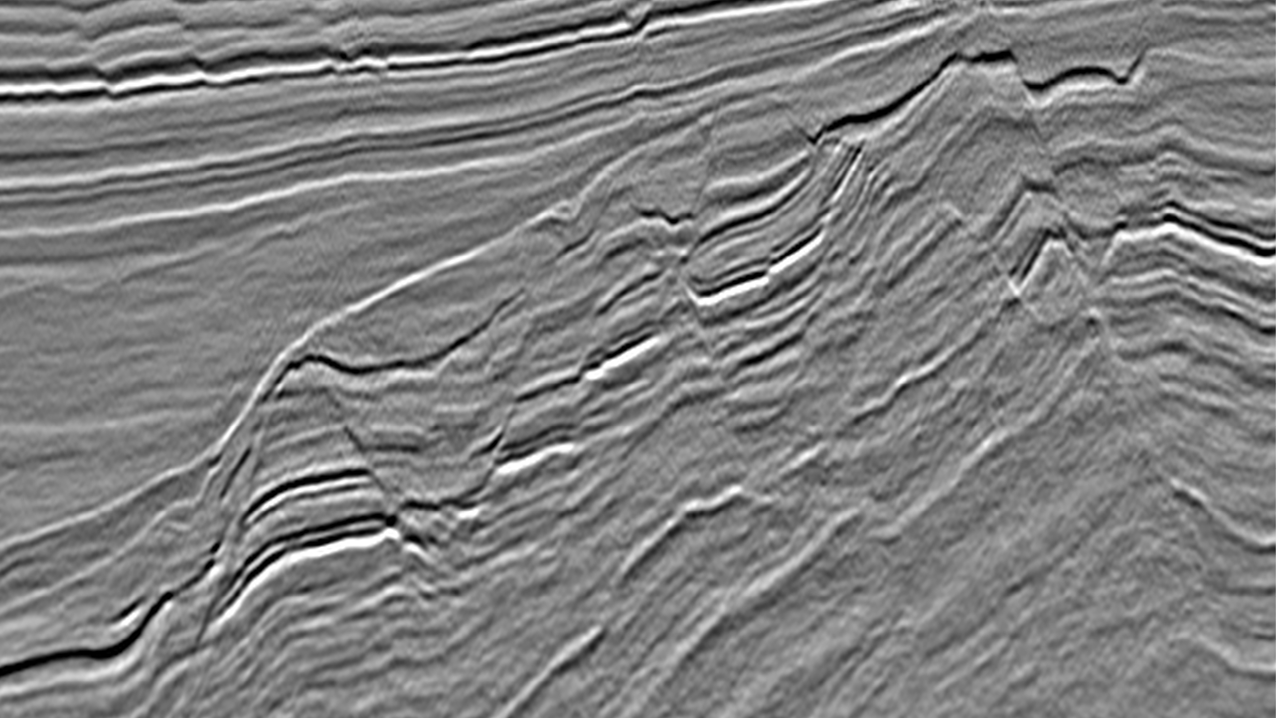
This GeoStreamer X full stack section from the Norwegian Sea is taken from an early-output volume from the 2022 program. The section is depth migrated and includes the Sør High, Dønna Terrace, Ytreholmen Fault Zone and crosses the Urd and Verdande areas. The section represents the dominant Lower Cretaceous (Lysing and Lange) and Jurassic plays (Fangst and Båt Group). Area 1 illustrates an example of fairly shallow and highly segmented Jurassic fault blocks on the Sør High while area 2 displays the Lower Cretaceous basin fill underlain by deeply buried Jurassic fault blocks showing variable preserved Early and Middle Jurassic sections in the Dønna Terrace.
Geological Setting and Challenges in The Norwegian Sea
The Norwegian Sea is known for good-quality hydrocarbon reservoirs and complex geology. Tilted fault blocks created by Late Jurassic rifting host prolific pre-rift petroleum plays, which consist of high-quality Jurassic sandstone reservoirs in structural traps. However, improved seismic data has led to an increased focus on marine post-rift deep-water clastic systems and stratigraphic traps in the Cretaceous section. Increased interest on the Cretaceous section combined with exploration potential in undrilled Jurassic structures and potential within the Paleocene and Triassic makes the Norwegian Sea attractive for continued exploration.
Warka, 6507/2-6, Slagugle, and Iris/Hades are all recent discoveries that prove the considerable remaining potential in the Norwegian Sea. High-quality seismic data is key to overcome subsurface imaging challenges and provide an accurate representation of the subsurface. The overburden in the Norwegian Sea may seem simple at first. However, periods of subsidence, uplifting and erosion have resulted in an overburden characterized by high impedance contrasts, rough surfaces, complex velocities, and complex anisotropy. In addition, shallow glacial morphology generates strong noise and multiples, affecting not only shallow targets but deeper targets as well.
GeoStreamer X: Innovative Acquisition and Rich Azimuthal Coverage
The GeoStreamer X 2022 acquisition program in the Norwegian Sea encompasses an area of approximately 6 700 sq. km, with an azimuth orientation perpendicular to the existing GeoStreamer dataset acquired between 2011 and 2016. Together the state-of-the-art depth imaging and the reprocessing of the existing data creates a uniform and large-scale multi-azimuth dataset in the region.
The innovative GeoStreamer X configuration utilizes a wide-tow triple source setup that allows for denser sampling in the crossline direction, longer cables for improved Full Waveform Inversion (FWI), and streamers towed as closely as possible to the source arrays. In this case, the source array separation was 250 m between outer arrays, and the data was recorded with 14 streamers spaced at 75 m intervals (12x7 km and 2x10 km long).
This acquisition setup significantly improves the near-offset distribution and provides rich azimuthal coverage. This enables a step change in data quality in the Norwegian Sea, helping to solve remaining imaging challenges in, for example, complex overburden structures, but also in areas with weaker reflectivity such as the Cretaceous. It also reveals the deeper potential in the region.
A modern pre-processing sequence ensures seamless merging of all azimuths into a single dataset before Q Kirchhoff Pre-Stack Depth Migration (Q-KPSDM). The velocity model will be obtained through comprehensive Velocity Model Building (VMB), including the use of both refractions and reflections for FWI in a multi-azimuth setting. This is crucial for resolving both shallow and deep velocity anomalies, such as channels, shallow gas, or velocity variations at Cretaceous and Jurassic reservoir levels.
Derisking with Enhanced Imaging
GeoStreamer X products have proven clear uplift in terms of continuity and resolution of reflectors as well as improvements in the interpretability, definition of the faults, and structural-stratigraphic geometries. Enhanced imaging leads to better interpretation, understanding of the reservoir and reservoir property estimation. This improves risk assessment and reduces uncertainty, allowing a more accurate estimation of subsurface reserve distributions and optimized exploitation strategies.
A high-quality early output volume is available now and is one of the products from the ongoing GeoStreamer X 2022 program. The deliverables for this product include pre-stack gathers, final stacks with up to six angle ranges and velocities. A modern processing sequence has been used for the acquired 2022 data while the legacy data has been picked up from the demultiple shot gather stage.
The data from all surveys was used and split into azimuth sectors prior to 5D regularization and Q-KPSDM with a legacy velocity model. The early-output volume already demonstrates the benefits of a GeoStreamer X solution compared to existing high-quality 3D in the Norwegian Sea, enabling early prospect evaluation half a year before the full integrity product delivery.
Multi-azimuth imaging gives improved signal-to-noise (s/n), increasing fault plane definition and reflector termination against faults (see figure above). Different acquisition directions affect the imaging of fault blocks and internal reflector geometries (shown below). The latter is prominent in the Lower Cretaceous section and underlying deeply buried Jurassic fault blocks, where the difference in reflector continuity between each single azimuth is compensated in the GeoStreamer X product.
Identifying and Unlocking Prospectivity with GeoStreamer X
In the Norwegian Sea, both petroleum exploration and appraisal/development drilling will continue to target more complex plays. This requires higher resolution, significantly improved s/n ratio and AVO friendly datasets that can capture structural and stratigraphic details, allowing for a proper risk and uncertainty quantification assessment of any reservoirs and traps. Recent drilling demonstrates that significant potential still remains in mature inboard locations, i.e. in conventional shallow targets and in field development extensions. The key to evaluating these opportunities is high-quality seismic data that provides a more complete illumination of the subsurface than with single azimuth data.
We have demonstrated that the regional GeoStreamer X data fulfill the requirements for a high-quality dataset in the Norwegian Sea. The data is suitable for exploring new and appraising existing finds. The dataset delivers a clear and more accurate view of the subsurface with improved resolution and reliable pre-stack amplitudes. In addition, the added azimuth helps to understand complex fault structures, lateral amplitude variations and reflector geometry.
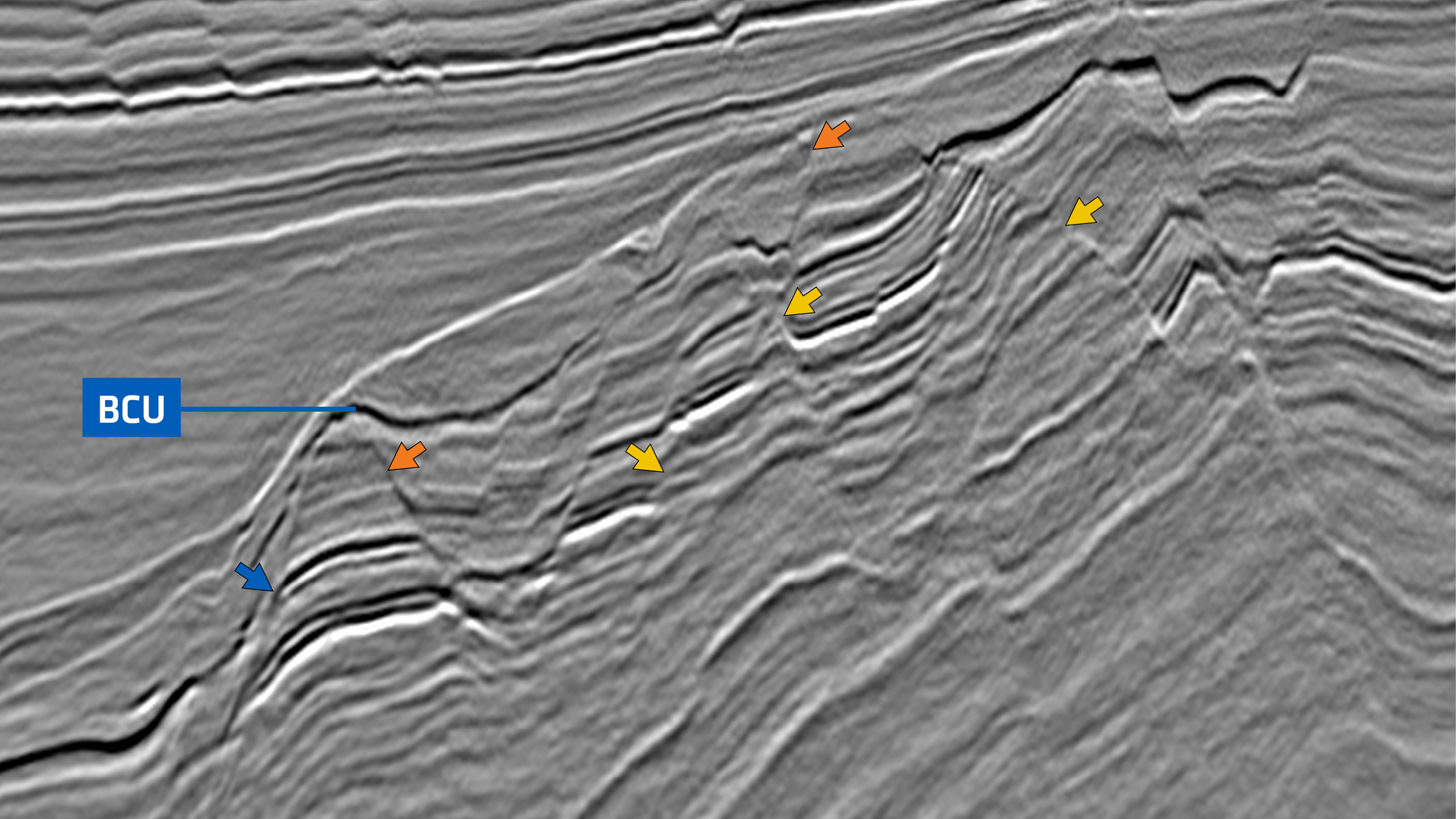
Close-up of the deep Dønna Terrace Lower Cretaceous basin and underlying Jurassic fault blocks in GeoStreamer X, single Azimuth 34 and single Azimuth 124 displays. Note the difference in internal reflector geometry, continuity and baselap between the single azimuths and the GeoStreamer X section (orange arrows). Lateral amplitude variations in individual reflectors are indicated. Subtle differences in faulting of the Cretaceous are visible, exemplified by the Verdande base amplitude shut off in the Lower Cretaceous (yellow arrow). High impedance contrast reflectors presumably are interbedded coals in the Åre Formation (blue arrows).
Contact a PGS expert
Please contact a member of our Europe team for more information.