

The operator is responsible for assessing and mitigating hazards before drilling, however, the traditional approach of commissioning a dedicated site survey is time-consuming, expensive, and can offer limited coverage. Running SWIM on your 3D volume offers a faster and more flexible method to analyze shallow hazards.
SWIM Benefits
- Separated wavefield imaging (SWIM) is an innovative geophysical solution that harnesses sea-surface seismic reflections to provide better-resolution imaging of the shallow subsurface
- Reprocessing is faster than acquiring new data and there are no time-sharing or weather issues
- Shallow hazard evaluation on 3D data allows a broader assessment, including several exploration sites
The objective of a site survey is to identify all possible constraints and hazards from man-made, natural, and geological features, which may affect the operational or environmental integrity of a proposed drilling operation. Based on the results, appropriate operational practices can be put in place to mitigate any risks identified (IOGP report number 373-18-1, 2017).
The requirements for a geohazard study are:
- Cover any conceivable well locations
- Provide sufficient data to analyze possible top-hole drilling hazards
- Data quality directly related to the actual conditions expected in the area of interest
In shallow water (< 250 m), this means a separate site survey dataset might be needed, as conventionally acquired seismic data may not have the required illumination or angular diversity in which to perform appropriate analysis.
SWIM to the Rescue
PGS SWIM uses separated upgoing and downgoing wavefields (P-UP and P-DWN) to turn each seismic receiver into a virtual source. Reflections from the sea surface are exploited to increase illumination during imaging. Shallow acquisition footprints are compensated and shallow resolution is substantially improved.
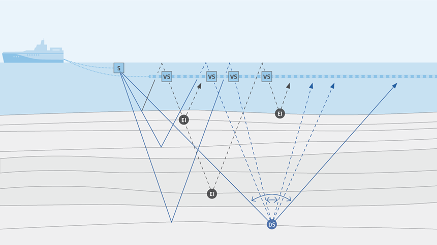 With SWIM imaging, each receiver is turned into a virtual source (VS), enabling the exploitation of sea-surface reflections for extra illumination (EI). This improves near-surface imaging in shallow-water data
SWIM is also a powerful tool for ocean bottom surveys acquired with nodes or cables. Using reciprocity, SWIM enables the benefits of extending the illumination well beyond that of the receiver array.
Regulations and Guidelines
No legal requirements define site survey data quality, so the onus is on the operator to use the appropriate data to accurately describe the challenges they may face in the environment they are exploring. However, there are guidelines. The International Association of Oil and Gas Producers (IOGP) produce guidelines for the conduct of offshore drilling hazard site surveys. IOGP report 373-18-1 and the associated technical notes (Report 373-18-2) provide detailed descriptions of the data requirements for specific scenarios.
Before performing a site survey, the IOGP recommends a desk study to assess the data needs for a geohazard study. The guidelines suggest:
- Exploration 3D data for site surveys should be used at the optimal spatial, temporal, bit resolution and sampling interval
- The dataset should provide sufficient resolution of the seabed and shallow section to allow accurate analysis of conditions to be made
They detail several specific requirements including:
- Frequency content should be up to, and preferably beyond 60 Hz to the full depth of interest below the seabed
- The seafloor reflection should be free of gaps and easily auto-tracked with minimum user intervention
- No or minimal acquisition artifacts should be present that might interfere with the mapping of shallow amplitudes
- A 25 m x 25 m bin size is the coarsest sampling, and ideally finer sampling is used
- The sample interval should preferably be 2 ms, and never more than 4 ms
- The data should be imaged with an accurate velocity model, ideally created using Full Waveform Inversion (FWI)
- Multiples should not contaminate the data
As long as the data used to perform the geohazard assessment fulfills these guidelines, it should have sufficient resolution to enable an effective site survey.
In deep water, the use of large-scale 3D seismic volumes will provide data fit for site surveys, assuming the acquisition geometry provides the appropriate spatial sampling. In shallow water, the acquisition geometry may not be suitable for near-surface imaging with conventional algorithms. The lack of near-offset information means only high reflection angles are recorded, which can cause imaging gaps that are visible in seismic data as an illumination or acquisition footprint.

SWIM for Geohazard Analysis
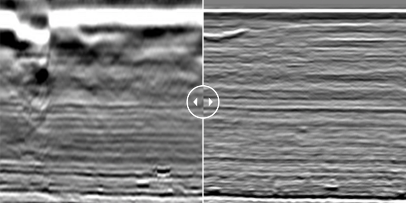
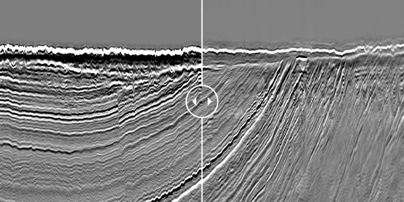
Workflows that combine high-resolution 3D processing with SWIM enable very detailed hazard assessment on existing 3D seismic data. This is a smart and cost-effective use of data that has already been acquired and it delivers data suitable for geohazard analysis over an entire existing 3D survey area. That provides increased flexibility to move well locations, as the analysis is not constrained by the sparse 2D grid of a bespoke site survey acquisition.
Several data examples are given below.
Cost-effective Solutions from PGS Toolkit
In shallow-water environments, SWIM enables the resolution needed to meet the international guidelines for site survey data quality and it can be applied on all data that can provide separated wavefields. It allows operators to use their existing data to create survey-wide datasets for shallow hazard analysis, bypassing the time-consuming process of acquiring expensive and geographically limited boutique site surveys.
The PGS imaging toolkit uses separated wavefields to unlock the illumination benefits of free-surface multiples. This can be used to benefit the processing and interpretation of data in a multitude of ways, of which shallow hazard imaging is just one. Another example is quality control in FWI model building. You can find out more about SWIM on our website www.pgs.com/swim.
Examples
Examples
Contact a PGS expert
If you have a question related to our Imaging & Characterization services or would like to request a quotation, please get in touch.