

PGS’ innovative data domain Least-Squares Migration (LSM) delivers high resolution images with more reliable amplitudes to provide accurate rock and fluid properties and derisk exploration. It uses detailed earth models, created using Full Waveform Inversion (FWI) and geological constraints, to iteratively obtain an optimal image of the earth’s subsurface.
LSM has emerged as new standard in high-end imaging, providing the level of resolution and amplitude fidelity necessary for prospect risk mitigation, reservoir characterization and well planning. A recent application of PGS LSM to data from the Buzios field, in the Santos Basin, Brazil, proves the benefit of the technology at all stratigraphic levels, but most importantly in the presalt plays.
PGS’ Santos Vision program, covers 49 000 sq. km of the prolific Santos Basin, and delivers on the industry’s demand for accurate seismic imaging of presalt hydrocarbon plays offshore Brazil. While existing products, based on conventional imaging solutions such as Kirchhoff Prestack Depth Migration (KPSDM) and Reverse Time Migration (RTM) provide a level of seismic detail that helps outline prospects and capture the hydrocarbon reservoirs, LSM has taken the imaging and characterization of reservoirs to new levels.
A Superior Image Starts with a Good Velocity Model
Reservoir targets in the Santos Basin are primarily presalt carbonate build-ups underneath a heterogeneous section of salt. The major industry focus on the presalt hydrocarbons requires precise seismic imaging to minimize uncertainties in reservoir definition. Therefore, building an accurate and detailed velocity model for the reservoirs is key to the Santos Vision program. A unique implementation of FWI utilizing the complete seismic wavefield generated an accurate and geologically consistent velocity model down through the presalt section. An understanding of the Layered Evaporite Sequence (LES, salt) complexity and the heterogeneity of the postsalt carbonate layers was incorporated in the model building process. The final velocity model successfully captured the variability in the postsalt sediments, including the Albian carbonates and the LES.
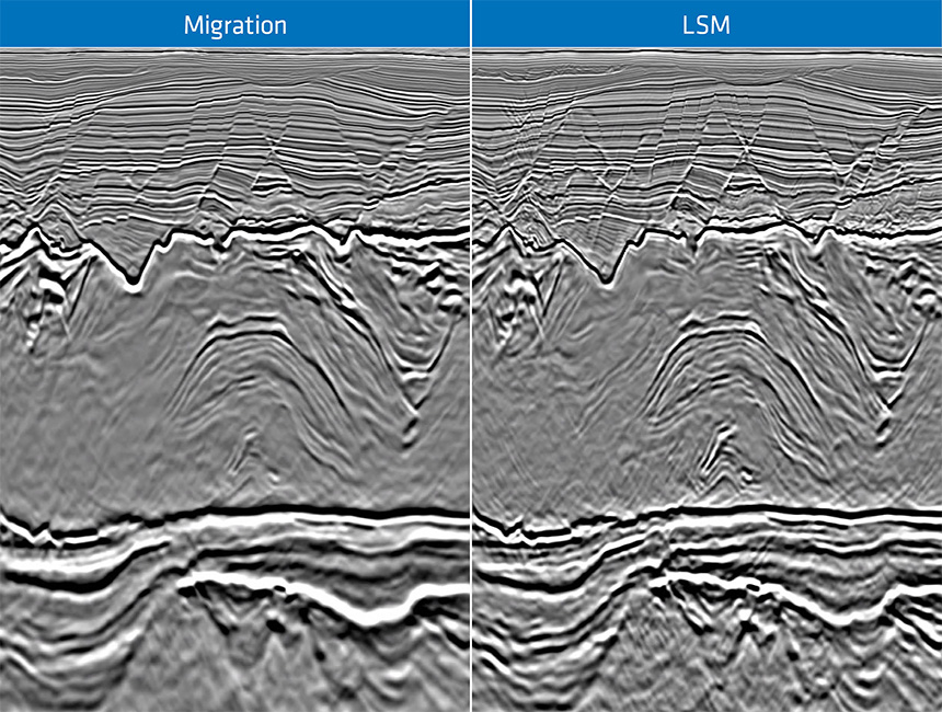
Imaging by Inversion with Data Domain Least-Squares Migration
Even with an accurate velocity model, conventional depth migration only produces an approximation of the earth’s true reflectivity. The main limitations are attributed to incomplete acquisition and variable illumination beneath a complex overburden (i.e. salt or carbonates). Therefore, migrated images often suffer from limited wavenumber content and reduced granularity, especially in the presalt. LSM on the other hand, tackles the limitations by posing the seismic imaging problem as an inversion process seeking optimal images closely representing the earth’s reflectivity.
While most commercial LSM algorithms are implemented as multi-dimensional deconvolutions in the image space, the PGS data domain LSM algorithm solves for the earth reflectivity by means of an iterative data-fitting workflow similar to FWI. More than one iteration of data modeling and migration are often necessary to obtain the optimal image. The engine of PGS LSM efficiently propagates high-frequency seismic data using the detailed earth models derived from FWI and in-depth interpretation. The results are high resolution images with balanced amplitudes and reduced illumination variations. The reflectivity models have more reliable amplitudes and are more suitable for quantitative reservoir characterization.
PGS LSM Improving Target Definition and Mitigating Risk
The PGS iterative, data domain LSM was applied over the Buzios field in the Santos Basin to exemplify the inversion approach on presalt reservoirs. The results highlighted how fault patterns and stratigraphic geometries are better resolved with LSM. They provide significant uplift for prospect maturation and reservoir characterization. The PGS LSM enhances image resolution, mitigates compartmentalization risk, resolves depositional signatures, and limits uncertainties in seismic stratigraphy characterization of reservoir facies variation. PGS LSM technology proved to be beneficial at all stratigraphic levels of the Santos Basin, but most importantly in the prolific presalt play.
Contact a PGS expert
Please contact a member of our Brazil team for more information.