

SWIM is a PGS full-wavefield imaging application that can be used on multisensor or multicomponent seismic data.
- Applicable to any multisensor towed-streamer or OBS data
- Shallow geology can be imaged with superior resolution
- Permits cost-effective wide-tow streamer acquisition in shallow water without sail-line illumination footprint
- Fit for shallow hazard imaging and shallow subsurface characterization increases angular diversity
- Can be seamlessly merged with deeper seismic images
- Can be used to assist in the prediction and removal of multiples that affect larger depths
- Both multiples and primaries can be simultaneously imaged in rich-azimuth surveys and hybrid streamer/node surveys
After wavefield separation, the two complementary wavefields enable multiples to be used in imaging workflows. Historically, these were treated as unwanted noise.
From an acquisition geometry perspective, every receiver location becomes a virtual source location. The original multisensor dataset is effectively reconfigured into a survey with incredibly dense illumination. SWIM images can be produced over the full recorded frequency bandwidth if desired, and seamlessly merged with traditional depth images to yield high-resolution images for all depths below the seafloor. AVO-compliant pre-stack SWIM gathers are also available.
Shallow Imaging
Depth-migrated SWIM shot gathers or stacks can be used in various innovative ways.
For shallow-water areas, where traditional multiple removal methods fail in processing, SWIM can be used to yield high-fidelity imaging of the seafloor reflector and the near surface. This model is then used to model multiple wavefields for subsequent subtraction.
For shallow geohazard imaging, SWIM can yield superior images than traditional towed-streamer and OBS imaging. Shallow images produced in this way can be seamlessly merged with Kirchhoff or RTM images in a cost-effective manner in areas where the shallow image resolution and quality need to be upgraded.
Shallow pre-stack simultaneous amplitude-versus-angle (AVA) studies can be produced, where conventional pre-stack data lacks the required angle range because of acquisition footprint effects.
FWM extends SWIM to Simultaneously Image Both Primary Reflections and Multiples
For data acquired with multisensor ocean bottom seismic, it may also be desirable to image both multiples and primary reflection data together, in one workflow. FWM is a novel imaging solution particularly suited to multisensor OBS data with a diverse range of offset and azimuth sampling. The least-squares implementation of FWM (LS-FWM) can produce clear seismic images from the seafloor to subsalt / presalt targets, and benefits include attenuation of various imaging artifacts often associated with subsalt imaging.
SWIM could be applied to single-sensor streamer seismic data by making some assumptions on the sea surface.
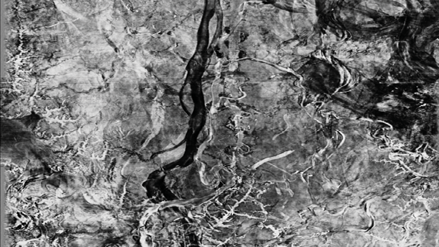
North Sea example showing significant improvement from the 2019 final prestack depth migration stack (bottom) with the SWIM high-resolution reprocessing which has significantly increased vertical and spatial resolution
Contact a PGS expert
If you have a question related to our Imaging & Characterization services or would like to request a quotation, please get in touch.