

Hot Topics in an Uncertain Climate
It has been a strange time for the energy industry in North America. The global squeeze on fuel prices at the bowser are for many a sign of the future if governments continue to persecute the oil and gas industry in a zero-sum game tactic to accelerate the growth of low carbon alternative energy sources. Confusion has been compounded for many by apparently ambiguous demands from the US government to oil companies to increase daily production, reduce prices, and simultaneously transition away from hydrocarbons within the next generation.
It is no surprise that the IMAGE22 program will include 17 emerging focus panels that address several of this year’s most talked about, debated, researched, and funded topics. The exhibit floor will feature new content focus areas such as near surface, digitalization, carbon management, and global energy (each also highlighted in the home page to the IMAGE22 event at https://www.imageevent.org/). Energy transition and sustainability talks will dive into energy efficiency, young professionals’ role in advancing sustainability, and progress of the Geoscience Sustainability Atlas. Carbon capture, utilization, and storage (CCUS) panel sessions will invite top professionals to address innovative technologies applicable to CCUS currently and in the future and will lay out the plan for building a successful CCUS team. Near-surface panels will discuss the future of academia as it relates to geophysics and introduce two bipartisan infrastructure-funded U.S. Department of Energy (DOE) programs: roads and bridges and abandoned wells methane emission mitigation. Deepwater petroleum exploration and production will celebrate 157 Years of excellence and offer an opportunity to discuss the past, present, and future state of the science of deepwater sedimentary systems and their applications to the energy industry.
A technical program of more than 920 presentations and talks will cover 34 foundational and developing geophysics and geology (G&G) topics. Seven are fully integrated G&G subjects in applied geoscience such as geotechnical advances in oil and gas development, borehole geophysics and geomechanics, low carbon solutions, geological and geophysical interpretation, deep integration of data and disciplines, machine learning, new energy frontiers, sustainable energy development, and environmental geoscience. The hottest topics are machine learning, full-waveform inversion, and interpretation, and the global special session focus for 2022 will be the Middle East. Eight other special sessions will include traditional Recent Advances and the Road Ahead, Geoscientists without Borders, hydrogeophysics, and other timely topics including electromagnetics, gravity, reserves, instrumentation, and so on.
PGS Contributions to IMAGE22
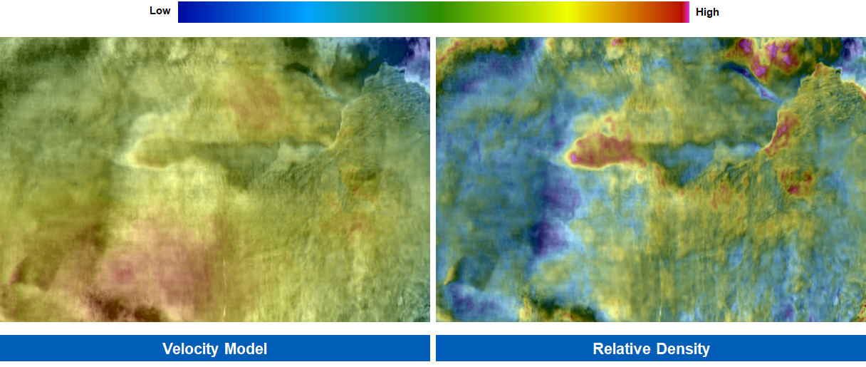
We will present 10 technical talks in the main program and two in the post-convention workshops. Six talks showcase PGS leadership in FWI and notably, the simultaneous inversion solution known commercially as “PGS Ultima”. In addition to an elegant and robust computation of velocity and reflectivity models, relative density can also be determined in one step.
There is no question that wider towing of multi-source configurations has enabled towed streamer seismic to deliver significantly improved near offset coverage and near-surface seismic image resolution in two years. “A novel marine survey configuration for the Sarawak Basin: Combining a wide-tow triple source with a non-uniform streamer spread” presents a pragmatic combination of a wide-tow triple source with a non-uniform streamer configuration in offshore Malaysia to further enhance data sampling and survey efficiency.
The “Continuous wavefields method” also known as “eSeismic” also promises to improve efficiency because acquisition speed is not penalized to avoid excessive blending of simultaneously fired sources. “Efficient acquisition and imaging of high-resolution seismic data with the continuous wavefields method” revisits a dataset acquired in offshore Brazil and pursues a processing flow designed to extend the spatial and temporal bandwidth of the data. Potential high-resolution applications include shallow hazard analysis or CCS monitoring.
Two presentations consider different aspects of multi-azimuth (MAZ) shooting. “Integrating legacy data with new towed-streamer acquisition tuned for imaging objectives: a Campos Basin case study” describes improved seismic imaging over 8 200 sq. km of data when a new dataset was acquired orthogonally to a legacy CLO (continuous long offset) dataset. Robust velocity model building and enhanced image quality have complemented interpretation and reservoir characterization. Indeed, the rejuvenation of legacy datasets via the acquisition of a new survey azimuth(s) is becoming commonplace in many regions. “Reservoir properties estimation using MAZ towed multisensor streamer seismic: A Norwegian case study” showcases the value of jointly inverting the pre-stack data from each azimuth to create opportunities for near-field exploration. Reservoir properties such as volume of shale and porosity are robustly estimated, and of other significance, no low-frequency model is necessary to derive absolute properties.
FWI (Full Waveform Inversion) continues to have a high industry profile, and PGS will present four related talks in the main technical program and two in the workshops program. Regards traditional FWI workflows, “Low frequency data reconstruction for Full Waveform Inversion” describes how a recursive filter estimated from the high-frequency content of the data is used to reconstruct the low frequencies of shot gathers so that risks of cycle skipping are reduced, and model convergence is faster and more stable. “A case study using FWI to image pre-Messinian target in the East Mediterranean Sea” presents a velocity model building workflow using FWI and RTM gathers that successfully captured historically elusive post-Messinian and-Messinian complexities in the eastern Mediterranean Sea, resulting in improved imaging of pre-Messinian targets.
“Simultaneous inversion of velocity and reflectivity for enhanced seismic imaging” extends the “PGS Ultima” methodology introduced in 2021 to simultaneously estimate both velocity and earth reflectivity. 3D data from offshore Newfoundland and Canada are used to deliver high fidelity quantitative interpretation products that include relative density in an elegant manner. “Nonlinear LS-RTM based on the seismic scale separation and full wavefield multi-parameter FWI” also illustrates how the methodology is insensitive to reflectivity changes associated with density variations and avoids erroneous velocity updates associated with traditional FWI. PGS Ultima results from the Norwegian Sea show significant structural improvements in reflectivity in comparison to conventional RTM images, with a better event focusing and fault resolution. “Least squares wavefield migration” and “Estimating subsurface properties with simultaneous inversion” in post-convention workshops W-3 and W-17, respectively, will further explore the opportunities provided by the PGS Ultima simultaneous inversion methodology.
An integrated G&G screening workflow to consider both the container and containment aspects of CCS will be presented in “Integrated workflow for characterization of CO2 subsurface storage sites”. The site assessment workflow allows the validation of various technologies on a local scale, with the option and feasibility to be expanded regionally. As the industry profile of CCS grows rapidly in the coming years, traditional reservoir monitoring by time-lapse (4D) seismic will adopt a greater focus upon observable changes in the overburden geology. Of relevance, “Water column corrections, joint water velocity inversion for 4D surveys” will present a new methodology for correcting the effect of the water layer variability on time-lapse seismic datasets that is significantly beneficial for deepwater ‘4D friendly’ data. The main difference from conventional approaches is the simultaneous use of both 4D datasets to estimate the water velocity changes and therefore minimize the seismic difference in the overburden. Inversion is performed in the image domain using cross-image CDP gathers built from cross-correlations of acquisition sequences of migrated data.