

PGS’ largest ever migration has recently been completed to deliver the final data products for Santos Vision. More than 34 000 sq. km of seismic data from 11 separate surveys have been merged into a single, seamless, high-quality broadband product covering a large swath of the prolific Santos Basin.
Sub-surface Geology Better Understood with Innovative Seismic Solutions
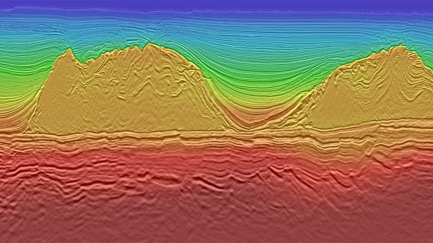
Challenges in the Santos Basin primarily relate to the reservoir targets, which are localized in presalt carbonate build-ups underneath heterogeneously layered evaporate sequences (LES, i.e. salt) and interbedded with volcanic rocks. On legacy data the presalt image is not well expressed, so the complexity of the salt and the differing character of the post-salt carbonates throughout the area needs to be understood and incorporated into the velocity model building process. The high degree of complexity within the LES, and the presence of areas with good reflectivity and others with little or no reflectivity must be accounted for in the modeling to obtain clear images in the presalt.
One major objective of the reprocessing was to image the presalt stratigraphic signature and rift architecture as these are directly related to the play type characterized by pre-salt carbonate buildups along tilted or uplifted fault block highs. Santos Vision delivers high granularity imaging of the base salt, reveals reservoir presence and accurate imaging of the rift fault patterns beneath the salt mitigates the risk of CO2 invasion.
- Case study - Seamless and Accurate Regional Presalt Imaging, Santos, Brazil
- Hotspot - Santos Area, Brazil
- Data library - Santos and Campos
Utilizing a velocity modeling process that avoids a hard velocity boundary at the base of the salt has enabled the production of a high quality image. A data driven approach was favored with continuous velocity updates throughout the salt and the presalt section using both Full Waveform Inversion (FWI) and tomography for velocity model building. The velocity updates were rigorously validated against geological conformity and structural constraints.
A Clear Image Needs a Good Velocity Model
One large, consistent velocity model is available for Santos Vision. It was built using a combination of geological interpretation, hyperTomo and FWI through the post-salt sediments to achieve an optimum and accurate velocity model of the area. Capturing the variability in the post-salt Albian carbonates and the avoidance of a hard velocity boundary at the base of the salt were key to this solution.
On a regional level, a domain approach addressed the variability in post-rift architecture including the character of the dominant salt geometries and associated post-salt sediment cover. Our unique implementation of FWI utilizing the full wavefield was deployed and following the success of FWI in the post-salt sediments it was pushed deeper than ever before. Reflection based FWI enabled robust velocity updates in the pre-salt section and down to the acoustic basement throughout the entire 34 000 sq. km area.
Presalt imaging is key for mitigating risk in the area. A data driven approach utilizing both Full Waveform Inversion (FWI) and tomography generated continuous velocity model updates through the salt and into the presalt, this avoids an imprecise horizon-based velocity boundary at the base of salt.
Imaging Solutions for Complex Challenges
Merging 11 surveys of varying acquisition vintages and layouts to provide a seamless broadband dataset is not straightforward. The solution was a robust broadband processing sequence and a monster RTM migration, using a much greater number of angle gathers than the industry standard, to deliver consistent quality over the whole area. The result is an excellent presalt image, better than previously achieved, and the advantage is being able to pick and choose data without worrying about consistency.
Imaging deliverables include a full bandwidth Kirchhoff high fidelity image and 35Hz RTM and Least Square Migration images, which feature illumination based amplitude compensation for better pre-salt resolution and rift fault imaging.
A Product for Determining Leads and Mitigating Risk
Now with a large scale view in a single dataset, Santos Vision offers exploration companies access to accurate data and images to improve exploration, reduce risk and create their own vision of this prolific basin.
The successful workflow developed here is applicable to the greater Santos and Campos basins and PGS has future reprocessing plans for the area.
Contact a PGS expert
Please contact a member of our Brazil team for more information.