

PGS’ Hammerfest Basin ultra-high-density high-resolution dataset is now available and will be extended further in 2020. Full integrity data includes open acreage, and resolves the challenges in this complex area through an innovative combination of streamer setup and advanced imaging technologies.
Key features are revealed with this dataset that extends from the Finnmark Platform in the southwest into the Hammerfest Basin in the northeast
- Deep marine sand deposits along the southern flank of the Hammerfest Basin show variable seismic amplitude anomalies
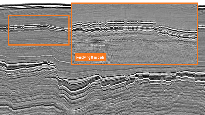
- The combination of densely recorded data and high-end imaging technologies result in a high-resolution seismic image. At Top Kolmule the tuning thickness is reduced down to approximately 8 m
- Clear identification of seismic amplitude anomalies within various stratigraphic units.
- Structural traps in the Realgrunnen sandstones and Triassic fluvial channel deposits in the Snadd and Kobbe formation
More details and images can be viewed in our recent article in GEO magazine.
Diving Deeper to Resolve the Challenges of the Barents Sea
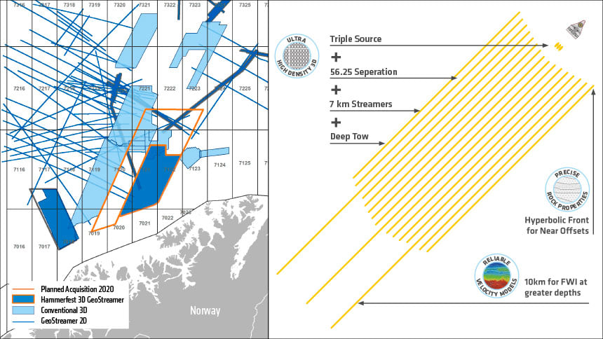
As shown in the image above, an innovative acquisition configuration was designed as the best solution to resolve mixed depth targets in the Barents Sea. It combines novel streamer setup and advanced imaging technologies.
Read more about this in our Barents Sea case study.
Open Acreage Opportunities
PGS’ planned 2020 survey extension includes open acreage in the Barents Sea (see locator map) and the overall area accounts for around half of the undiscovered resources on the NCS, according to the Norwegian Petroleum Directorate.
Key target areas for hydrocarbon plays in the southwestern Barents Sea are the shallow Kapp Toscana Group sandstones, and deeper, middle Triassic Kobbe Formation sandstones and potentially karstified, Carboniferous/Permian carbonates. Proven discoveries made in both geological regimes show the great hydrocarbon potential of this area, but a key challenge in producing an accurate image of the subsurface is creating a reliable velocity model that accounts for the area’s complex geological regime.
Integrated Solutions for Best Results
Tailored acquisition and imaging solutions provide the right seismic data in order to unlock shallow and deep targets in the Barents Sea. Ultra-high capacity vessels, like the PGS Ramform fleet, can operate with highly effective spreads with variable streamer lengths, e.g. including a sparse set of long streamers for FWI-based velocity model building. This acquisition and imaging concept offers the flexibility to address exploration challenges in the Barents Sea, as well as other basins with complex geological regimes around the world, by adding sources or operating with wide-tow source configurations.
Contact a PGS expert
Please contact a member of our AMME team for more information.