

With smarter acquisition and imaging solutions for resolving mixed target depths in the Barents Sea, PGS is diving deeper with FWI velocity model building. Newly available fast-track images from the survey prove industry-leading image resolution.
In 2018, the PGS ultra-high capacity vessel Ramform Atlas acquired an innovative ultra-high-density, variable streamer length survey over parts of the shallow Finnmark Platform and the deeper Hammerfest Basin. This seismic survey (4 100 sq. km) is unique with respect to spatial sampling, streamer spread design and offsets provided for exploration objectives. The PGS-TGS joint venture survey was acquired with multisensor GeoStreamer technology.
For stunning images from the Hammerfest Basin view our case study.
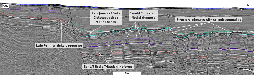
The south-western Barents Sea is characterized by a complex geological regime, with a heterogeneous overburden and different target depths. The combination of relatively shallow water depths and a hard, rugose sea floor, creates a tremendous amount of noise. This complicates using reflections in FWI for velocity updates. A key challenge in producing an accurate image of the subsurface is creating a reliable velocity model. Refraction based FWI has become the standard tool for velocity model building in the Barents Sea. However, until now there has been a lack of recorded long offsets and model depths have been limited. Identifying porous carbonate buildups and sands has previously been difficult on legacy seismic data.
2-for-1 Acquisition Solution: High-Resolution Imaging and Long-Offset Velocity Survey
The multisensor streamers, towed at a depth of 25 m, provide true broadband data with a high signal-to-noise ratio of the low frequencies for full waveform inversion (FWI) and quantitative interpretation (QI). A unique configuration with a variable streamer length was deployed to enable optimal imaging of both shallow and deeper targets and to provide long offsets for FWI. While the dense streamer separation of 56.25 m was configured with up to 7 km offset, three of the 16 streamers were deployed with 10 km streamer length (i.e., a high-density spread with sparser long-offset tails). On the near-offset end, the inline offsets were reduced to 88 m, and further optimized by a U-shaped staggering of the streamer front-ends.
For the Hammerfest Basin survey, a high-density 16 x 56.25 m multisensor streamer spread was combined with a triple-source configuration providing dense crossline sampling and a very broadband signal.
Diving Deeper to Reveal Hydrocarbon Potential
In a pre-survey study, the effect of various long-offset streamer separations on the FWI inversion was thoroughly analyzed. The study concluded that dense streamer spacing is not required for the longer offsets to obtain stable FWI updates. Thus, only three of the 16 streamers were extended to an offset of 10 km. Impressive velocity-model-building results from the ongoing processing and imaging effort show that refraction-based FWI provides updates up to 5 km depth when the 10 km offset range is used. The high-quality GeoStreamer data allows the FWI to start at frequencies as low as 2 Hz.
The key pre-processing steps in the high-resolution imaging workflow were 3D wavefield separation and source-side deghosting. In addition, the triple source data was deblended using a method enabled by the proprietary shot dithering applied during acquisition. The ultra-dense spatial sampling and the detailed velocity model derived from FWI, leads to the resolution of very thin beds in the Late Jurassic section. Frequencies as high as 200 Hz are imaged.
Tailored acquisition and imaging solutions provide the right seismic data in order to unlock shallow and deep targets in the Barents Sea. Ultra-high capacity vessels, like the PGS Ramform fleet, can operate with highly effective spreads with variable streamer lengths, e.g., including a sparse set of long streamers for FWI-based velocity model building. This acquisition and imaging concept offers the flexibility to address exploration challenges in other basins around the world by adding sources or operating with wide-tow source configurations.
Contact a PGS expert
Please contact a member of our AMME team for more information.